
Topografische kaart Hobart
Interactieve kaart
Klik op de kaart om de hoogte weer te geven.
Over deze kaart
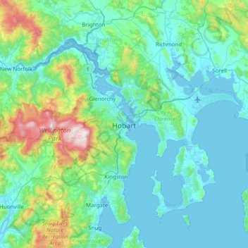
Naam: Topografische kaart Hobart, hoogte, reliëf.
Locatie: Hobart, City of Hobart, Tasmania, Australia (-43.10362 147.09169 -42.65538 147.64559)
Gemiddelde hoogte: 179 m
Minimale hoogte: -2 m
Maximale hoogte: 1.260 m
Although Hobart itself rarely receives snow during the winter due to the foehn effect created by the Central Highlands (the city's geographic position causes a rainshadow), the adjacent Kunanyi/Mount Wellington is frequently seen with a snowcap throughout the year including in summer. During the 20th century, the city itself has received snowfalls at sea level on average only once every 5 years; however, outer suburbs lying higher on the slopes of Mount Wellington receive snow more often, owing to the more exposed position coupled with them resting at higher altitude. These snow-bearing winds often carry on through Tasmania and Victoria to the Snowy Mountains in Victoria and southern New South Wales.
Andere topografische kaarten
Klik op een kaart om zijn topografie, zijn hoogte en zijn reliëf te bekijken.
Goulds Country
Goulds Country, Break O'Day, Tasmania, 7216, Australia
Gemiddelde hoogte: 308 m
Vale of Belvoir Conservation Area
Vale of Belvoir Conservation Area, Kentish, Tasmania, Australia
Gemiddelde hoogte: 866 m
Lake Belton
Lake Belton, Derwent Valley, Tasmania, Australia
Gemiddelde hoogte: 1.056 m
Erith Island
Erith Island, Flinders Council, Tasmania, Australia
Gemiddelde hoogte: 23 m
Chicken Island
Chicken Island, Huon Valley, Tasmania, Australia
Gemiddelde hoogte: 4 m
West Hobart
West Hobart, Hobart, City of Hobart, Tasmania, 7000, Australia
Gemiddelde hoogte: 105 m
Mount Nelson
Mount Nelson, Hobart, City of Hobart, Tasmania, 7007, Australia
Gemiddelde hoogte: 198 m
Lake Pedder
Australia > Tasmania > Strathgordon
Lake Pedder, Strathgordon, Derwent Valley, Tasmania, Australia
Gemiddelde hoogte: 366 m
Mersey Forest
Mersey Forest, Meander Valley, Tasmania, Australia
Gemiddelde hoogte: 866 m
Launceston
Launceston, City of Launceston, Tasmania, Australia
Gemiddelde hoogte: 194 m
Port Arthur
Port Arthur, Tasman, Tasmania, 7182, Australia
Gemiddelde hoogte: 153 m
Highland Waters
Australia > Tasmania > London Lakes
Highland Waters, London Lakes, Central Highlands, Tasmania, Australia
Gemiddelde hoogte: 759 m
Bullock Hill
Bullock Hill, Grove, Huon Valley, Tasmania, Australia
Gemiddelde hoogte: 147 m
Grey Mares Tail
Australia > Tasmania > St Marys
Grey Mares Tail, St Marys, Break O'Day, Tasmania, Australia
Gemiddelde hoogte: 349 m
Anderson Island
Anderson Island, Flinders Council, Tasmania, Australia
Gemiddelde hoogte: 4 m
Flinders Island
Flinders Island, Tasmania, 7255, Australia
Gemiddelde hoogte: 20 m
Macquarie Island
Macquarie Island, Huon Valley, Tasmania, Australia
Gemiddelde hoogte: 20 m
Bruny Island
Australia > Tasmania > Alonnah
Bruny Island, Alonnah, Kingborough, Tasmania, Australia
Gemiddelde hoogte: 59 m
Deal Island
Deal Island, Flinders Council, Tasmania, Australia
Gemiddelde hoogte: 45 m