
Topografische kaart Worcester County
Interactieve kaart
Klik op de kaart om de hoogte weer te geven.
Over deze kaart
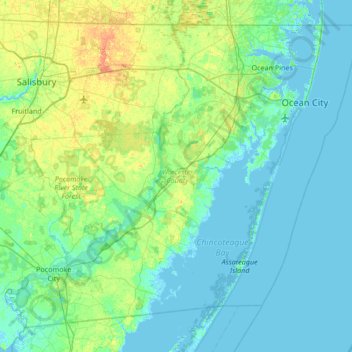
Naam: Topografische kaart Worcester County, hoogte, reliëf.
Locatie: Worcester County, Maryland, United States (37.99428 -75.66177 38.45204 -74.98520)
Gemiddelde hoogte: 6 m
Minimale hoogte: -3 m
Maximale hoogte: 28 m
The terrain is mostly level and coastal. The lowest elevation is sea level along the Atlantic Ocean and the highest elevation is 49 ft (15 m) in the northwestern part of the county along State Route 12 just south of the Wicomico County line.
Andere topografische kaarten
Klik op een kaart om zijn topografie, zijn hoogte en zijn reliëf te bekijken.
West Ocean City
United States > Maryland > Worcester County > West Ocean City
West Ocean City, Worcester County, Maryland, United States
Gemiddelde hoogte: 2 m
Ocean City
United States > Maryland > Worcester County
Ocean City, Worcester County, Maryland, United States
Gemiddelde hoogte: 1 m
Stockton
United States > Maryland > Worcester County > Stockton
Stockton, Worcester County, Maryland, United States
Gemiddelde hoogte: 8 m
Snow Hill
United States > Maryland > Worcester County
Snow Hill, Worcester County, Maryland, United States
Gemiddelde hoogte: 7 m
Ocean Pines
United States > Maryland > Worcester County
Ocean Pines, Worcester County, Maryland, United States
Gemiddelde hoogte: 3 m
Assateague Island National Seashore
United States > Maryland > Worcester County > West Ocean City
Assateague Island National Seashore, West Ocean City, Worcester County, Maryland, United States
Gemiddelde hoogte: 2 m
Newark
United States > Maryland > Worcester County > Newark
Newark, Worcester County, Maryland, United States
Gemiddelde hoogte: 10 m