
Topografische kaart Snow Hill
Interactieve kaart
Klik op de kaart om de hoogte weer te geven.
Over deze kaart
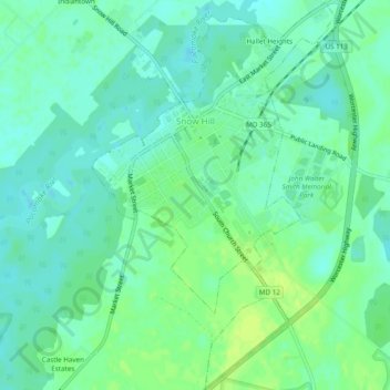
Naam: Topografische kaart Snow Hill, hoogte, reliëf.
Locatie: Snow Hill, Worcester County, Maryland, United States (38.15085 -75.40553 38.18877 -75.37540)
Gemiddelde hoogte: 7 m
Minimale hoogte: -1 m
Maximale hoogte: 15 m
Snow Hill was founded in 1686 in Somerset County by English settlers, who may have named it after a street and neighborhood of the City of London called "Snow Hill", despite the location's elevation of just 16 feet (4.9 m) above sea level and the infrequency of snowfall. The town received its first charter on October 26, 1686, and was made a port of entry in 1694.
Andere topografische kaarten
Klik op een kaart om zijn topografie, zijn hoogte en zijn reliëf te bekijken.
West Ocean City
United States > Maryland > Worcester County > West Ocean City
West Ocean City, Worcester County, Maryland, United States
Gemiddelde hoogte: 2 m
Ocean City
United States > Maryland > Worcester County
Ocean City, Worcester County, Maryland, United States
Gemiddelde hoogte: 1 m
Stockton
United States > Maryland > Worcester County > Stockton
Stockton, Worcester County, Maryland, United States
Gemiddelde hoogte: 8 m
Ocean Pines
United States > Maryland > Worcester County
Ocean Pines, Worcester County, Maryland, United States
Gemiddelde hoogte: 3 m
Assateague Island National Seashore
United States > Maryland > Worcester County > West Ocean City
Assateague Island National Seashore, West Ocean City, Worcester County, Maryland, United States
Gemiddelde hoogte: 2 m
Newark
United States > Maryland > Worcester County > Newark
Newark, Worcester County, Maryland, United States
Gemiddelde hoogte: 10 m
Worcester County
United States > Maryland > Worcester County
Worcester County, Maryland, United States
Gemiddelde hoogte: 6 m