
Topografische kaart Berea
Interactieve kaart
Klik op de kaart om de hoogte weer te geven.
Over deze kaart
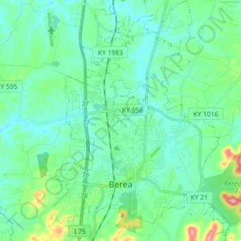
Naam: Topografische kaart Berea, hoogte, reliëf.
Locatie: Berea, Madison County, Kentucky, United States (37.54556 -84.33198 37.64341 -84.23968)
Gemiddelde hoogte: 300 m
Minimale hoogte: 261 m
Maximale hoogte: 463 m
Berea is located on the border of the Cumberland Plateau. The area has a mountainous appearance, but most outcroppings in the area have a maximum elevation of 2,500 feet or 760 metres.
Andere topografische kaarten
Klik op een kaart om zijn topografie, zijn hoogte en zijn reliëf te bekijken.
Redhouse
United States > Kentucky > Madison County
Redhouse, Madison County, Kentucky, United States
Gemiddelde hoogte: 248 m
Newby
United States > Kentucky > Madison County
Newby, Madison County, Kentucky, United States
Gemiddelde hoogte: 272 m
Welch Mountain
United States > Kentucky > Madison County
Welch Mountain, Madison County, Kentucky, 40404, United States
Gemiddelde hoogte: 315 m
Fort Boonesborough State Park
United States > Kentucky > Madison County > Boonesborough
Fort Boonesborough State Park, Boonesborough, Madison County, Kentucky, United States
Gemiddelde hoogte: 236 m
Richmond
United States > Kentucky > Madison County
Richmond, Madison County, Kentucky, 40475, United States
Gemiddelde hoogte: 281 m
Berea
United States > Kentucky > Madison County > Berea > Berea
Berea, Madison County, Kentucky, 40404, United States
Gemiddelde hoogte: 314 m
Richmond
United States > Kentucky > Madison County > Richmond
Richmond, Madison County, Kentucky, 40475, United States
Gemiddelde hoogte: 267 m