
Topografische kaart Miles City
Interactieve kaart
Klik op de kaart om de hoogte weer te geven.
Over deze kaart
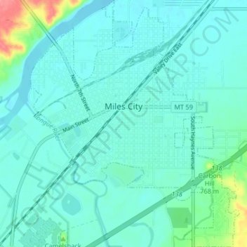
Naam: Topografische kaart Miles City, hoogte, reliëf.
Locatie: Miles City, Custer County, Montana, United States (46.38294 -105.86553 46.42780 -105.81047)
Gemiddelde hoogte: 724 m
Minimale hoogte: 711 m
Maximale hoogte: 794 m
Andere topografische kaarten
Klik op een kaart om zijn topografie, zijn hoogte en zijn reliëf te bekijken.
Westwood Estates
United States > Montana > Custer County > Miles City
Westwood Estates, Miles City, Custer County, Montana, 59301, United States
Gemiddelde hoogte: 724 m
Carbon Hill Trailer Court
United States > Montana > Custer County > Miles City
Carbon Hill Trailer Court, Miles City, Custer County, Montana, 59301, United States
Gemiddelde hoogte: 732 m
Cook Lake
United States > Montana > Custer County > Miles City > Smiths Trailer Court
Cook Lake, Smiths Trailer Court, Miles City, Custer County, Montana, United States
Gemiddelde hoogte: 721 m
Yellowstone River
United States > Montana > Custer County
Yellowstone River, Custer County, Montana, 59301, United States
Gemiddelde hoogte: 720 m