
Topografische kaart Yellowstone River
Interactieve kaart
Klik op de kaart om de hoogte weer te geven.
Over deze kaart
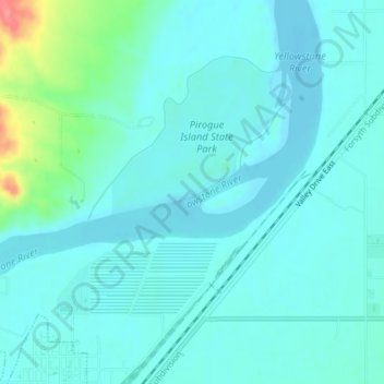
Naam: Topografische kaart Yellowstone River, hoogte, reliëf.
Gemiddelde hoogte: 720 m
Minimale hoogte: 707 m
Maximale hoogte: 786 m
The mainstem of the Yellowstone River is more than 700 miles (1,100 km) long. At the headwaters, elevations exceed 12,800 feet (3,900 m) above sea level and descends to 1,850 feet (560 m) at the confluence with the Missouri River in far western North Dakota. The watershed spans 34,167 square miles (88,490 km2). The area contains many lakes, including Yellowstone Lake. There are no storage dams located on the mainstem of the Yellowstone River. However, the watershed contains five major reservoirs built on tributary rivers: Bull Lake, Boysen, Buffalo Bill, Big Horn, Tongue River, and Lake De Smet reservoirs.
Andere topografische kaarten
Klik op een kaart om zijn topografie, zijn hoogte en zijn reliëf te bekijken.
Westwood Estates
United States > Montana > Custer County > Miles City
Westwood Estates, Miles City, Custer County, Montana, 59301, United States
Gemiddelde hoogte: 724 m
Carbon Hill Trailer Court
United States > Montana > Custer County > Miles City
Carbon Hill Trailer Court, Miles City, Custer County, Montana, 59301, United States
Gemiddelde hoogte: 732 m
Miles City
United States > Montana > Custer County
Miles City, Custer County, Montana, United States
Gemiddelde hoogte: 724 m
Cook Lake
United States > Montana > Custer County > Miles City > Smiths Trailer Court
Cook Lake, Smiths Trailer Court, Miles City, Custer County, Montana, United States
Gemiddelde hoogte: 721 m