
Topografische kaart Monroe Township
Interactieve kaart
Klik op de kaart om de hoogte weer te geven.
Over deze kaart
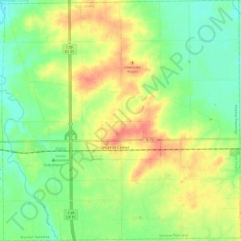
Naam: Topografische kaart Monroe Township, hoogte, reliëf.
Locatie: Monroe Township, Ogle County, Illinois, 61052, United States (42.06401 -89.05694 42.15233 -88.93889)
Gemiddelde hoogte: 243 m
Minimale hoogte: 219 m
Maximale hoogte: 274 m
Andere topografische kaarten
Klik op een kaart om zijn topografie, zijn hoogte en zijn reliëf te bekijken.
Grand Detour
United States > Illinois > Ogle County
Grand Detour, Grand Detour Township, Ogle County, Illinois, United States
Gemiddelde hoogte: 213 m
Oregon
United States > Illinois > Ogle County
Oregon, Oregon - Nashua Township, Ogle County, Illinois, 61061, United States
Gemiddelde hoogte: 223 m
Stillman Valley
United States > Illinois > Ogle County
Stillman Valley, Marion Township, Ogle County, Illinois, United States
Gemiddelde hoogte: 222 m
Rockvale Township
United States > Illinois > Ogle County
Rockvale Township, Ogle County, Illinois, United States
Gemiddelde hoogte: 239 m
Lost Nation
United States > Illinois > Ogle County
Lost Nation, Taylor Township, Ogle County, Illinois, United States
Gemiddelde hoogte: 223 m
Leaf River
United States > Illinois > Ogle County
Leaf River, Leaf River Township, Ogle County, Illinois, United States
Gemiddelde hoogte: 227 m
Byron
United States > Illinois > Ogle County > Byron
Byron, Ogle County, Illinois, 61010, United States
Gemiddelde hoogte: 226 m
Monroe Center
United States > Illinois > Ogle County
Monroe Center, Monroe Township, Ogle County, Illinois, United States
Gemiddelde hoogte: 254 m
Rochelle
United States > Illinois > Ogle County
Rochelle, Flagg Township, Ogle County, Illinois, 61068, United States
Gemiddelde hoogte: 243 m