
Topografische kaart Noatak
Interactieve kaart
Klik op de kaart om de hoogte weer te geven.
Over deze kaart
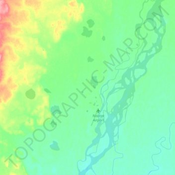
Naam: Topografische kaart Noatak, hoogte, reliëf.
Locatie: Noatak, Northwest Arctic, Alaska, United States (67.52037 -163.25985 67.64493 -162.93130)
Gemiddelde hoogte: 31 m
Minimale hoogte: 12 m
Maximale hoogte: 98 m
Andere topografische kaarten
Klik op een kaart om zijn topografie, zijn hoogte en zijn reliëf te bekijken.
Buckland
United States > Alaska > Northwest Arctic
Buckland, Northwest Arctic, Alaska, 99727, United States
Gemiddelde hoogte: 9 m
Kotzebue
United States > Alaska > Northwest Arctic
Kotzebue, Northwest Arctic, Alaska, United States
Gemiddelde hoogte: 9 m
Red Dog Mine
United States > Alaska > Northwest Arctic
Red Dog Mine, Northwest Arctic, Alaska, United States
Gemiddelde hoogte: 315 m
Mount Igikpak
United States > Alaska > Northwest Arctic
Mount Igikpak, Northwest Arctic, Alaska, United States
Gemiddelde hoogte: 1.728 m