
Topografische kaart Mount Igikpak
Interactieve kaart
Klik op de kaart om de hoogte weer te geven.
Over deze kaart
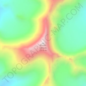
Naam: Topografische kaart Mount Igikpak, hoogte, reliëf.
Locatie: Mount Igikpak, Northwest Arctic, Alaska, United States (67.41261 -154.96478 67.41271 -154.96468)
Gemiddelde hoogte: 1.728 m
Minimale hoogte: 1.305 m
Maximale hoogte: 2.524 m
Andere topografische kaarten
Klik op een kaart om zijn topografie, zijn hoogte en zijn reliëf te bekijken.
Buckland
United States > Alaska > Northwest Arctic
Buckland, Northwest Arctic, Alaska, 99727, United States
Gemiddelde hoogte: 9 m
Noatak
United States > Alaska > Northwest Arctic
Noatak, Northwest Arctic, Alaska, United States
Gemiddelde hoogte: 31 m
Kotzebue
United States > Alaska > Northwest Arctic
Kotzebue, Northwest Arctic, Alaska, United States
Gemiddelde hoogte: 9 m
Red Dog Mine
United States > Alaska > Northwest Arctic
Red Dog Mine, Northwest Arctic, Alaska, United States
Gemiddelde hoogte: 315 m