
Topografische kaart Kouts
Interactieve kaart
Klik op de kaart om de hoogte weer te geven.
Over deze kaart
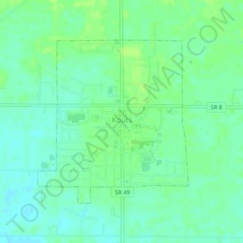
Naam: Topografische kaart Kouts, hoogte, reliëf.
Locatie: Kouts, Porter County, Indiana, 46347, United States (41.30745 -87.03836 41.32558 -87.01603)
Gemiddelde hoogte: 208 m
Minimale hoogte: 201 m
Maximale hoogte: 215 m
Andere topografische kaarten
Klik op een kaart om zijn topografie, zijn hoogte en zijn reliëf te bekijken.
Valparaiso
United States > Indiana > Porter County
Valparaiso, Porter County, Indiana, United States
Gemiddelde hoogte: 235 m
Indiana Dunes State Park
United States > Indiana > Porter County > Chesterton
Indiana Dunes State Park, 1600, Chesterton, Porter County, Indiana, 46304, United States
Gemiddelde hoogte: 186 m
Portage
United States > Indiana > Porter County
Portage, Porter County, Indiana, United States
Gemiddelde hoogte: 190 m
Burns Harbor
United States > Indiana > Porter County
Burns Harbor, Porter County, Indiana, United States
Gemiddelde hoogte: 189 m
Indiana Dunes National Park
United States > Indiana > Porter County > Portage
Indiana Dunes National Park, Portage, Porter County, Indiana, 46403, United States
Gemiddelde hoogte: 188 m
Ogden Dunes
United States > Indiana > Porter County
Ogden Dunes, Porter County, Indiana, United States
Gemiddelde hoogte: 184 m
Chesterton
United States > Indiana > Porter County
Chesterton, Porter County, Indiana, 46304, United States
Gemiddelde hoogte: 200 m
Chesterton
United States > Indiana > Porter County > Chesterton
Chesterton, Porter County, Indiana, 46304, United States
Gemiddelde hoogte: 197 m
Beverly Shores
United States > Indiana > Porter County > Beverly Shores > Beverly Shores
Beverly Shores, Porter County, Indiana, 46301, United States
Gemiddelde hoogte: 182 m
Hebron
United States > Indiana > Porter County
Hebron, Porter County, Indiana, 46341, United States
Gemiddelde hoogte: 213 m