
Topografische kaart Maramureș
Interactieve kaart
Klik op de kaart om de hoogte weer te geven.
Over deze kaart
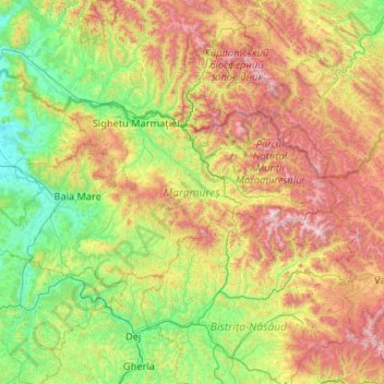
Naam: Topografische kaart Maramureș, hoogte, reliëf.
Locatie: Maramureș, Romania (47.32062 22.96148 48.02179 25.05644)
Gemiddelde hoogte: 700 m
Minimale hoogte: 131 m
Maximale hoogte: 2.238 m
Maramureș County is situated in the northern part of Romania, and has a border with Ukraine. This county has a total area of 6,304 square kilometres (2,434 sq mi), of which 43% is covered by the Rodna Mountains, with its tallest peak, Pietrosul [ro], at 2,303 metres (7,556 ft) altitude. Together with the Gutâi and Țibleș mountain ranges, the Rodna mountains are part of the Eastern Carpathians. The rest of the county are hills, plateaus, and valleys. The county is crossed by Tisa River and its main tributaries: the Iza, Vișeu, and Mara rivers.
Andere topografische kaarten
Klik op een kaart om zijn topografie, zijn hoogte en zijn reliëf te bekijken.
Lacul Mocearu
Lacul Mocearu, Vârteju, Chiliile, Buzău, 127307, Romania
Gemiddelde hoogte: 727 m
Bâsca Chiojdului
Bâsca Chiojdului, Chiojdu, Buzău, 127171, Romania
Gemiddelde hoogte: 732 m
Obârșia Lotrului
Obârșia Lotrului, Voineasa, Vâlcea, Romania
Gemiddelde hoogte: 1.500 m
Miercurea Ciuc
Romania > Harghita > Miercurea Ciuc
Miercurea Ciuc, Harghita, Romania
Gemiddelde hoogte: 689 m
Transylvania
Transylvania, Band, Mureș, 547065, Romania
Gemiddelde hoogte: 648 m
Tudor Vladimirescu
Tudor Vladimirescu, Tulcea, 820001, Romania
Gemiddelde hoogte: 15 m
Miercurea Ciuc
Romania > Harghita > Miercurea Ciuc
Miercurea Ciuc, Harghita, Romania
Gemiddelde hoogte: 873 m
Târgu Mureș
Târgu Mureș, Targu Mures Metropolitan Area, Mureș, Romania
Gemiddelde hoogte: 357 m
Moeciu de Jos
Romania > Brașov > Moeciu de Jos
Moeciu de Jos, Brașov, 507135, Romania
Gemiddelde hoogte: 900 m