Geolokaliseren

Topografische kaart Tomball

Klik op de kaart om de hoogte weer te geven.

Tomball

European settlement began in the Tomball area in the early 19th century, where newcomers found an open, fertile land that received adequate rainfall—perfect conditions for farming and raising cattle. It was on a land granted in 1838 to William Hurd's heirs. In 1906 the area began to boom. Railroad line engineers often noticed that the Tomball area was on the boundary between the low hills of Texas and the flat coastal plains of the Gulf, making it an ideal location for a train stop. The railroad could load more cargo on each car, because the topography gently sloped toward the Galveston ports and provided an easier downhill coast. Thomas Henry Ball, an attorney for the Trinity and Brazos Valley Railroad, convinced the railroad to run the line right through downtown Tomball. Soon after, people came in droves to this new train stop. Hotels, boarding houses, saloons, and mercantile stores all began to spring up in the area. At first, people called the area Peck, after a chief civil engineer of the railroad line. However, on December 2, 1907, the town was officially named Tom Ball, later to be shortened to one word, for Mr. Ball.

Wikipedia (CC-BY-SA 3.0)

Over deze kaart

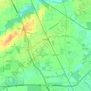
Naam: Topografische kaart Tomball, hoogte, reliëf.

Locatie: Tomball, Harris County, Texas, United States (30.04622 -95.66653 30.13601 -95.58413)

Gemiddelde hoogte: 52 m

Minimale hoogte: 37 m

Maximale hoogte: 77 m

Andere topografische kaarten

Klik op een kaart om zijn topografie, zijn hoogte en zijn reliëf te bekijken.

Cypress

United States > Texas > Harris County

Gemiddelde hoogte: 46 m

Spring

United States > Texas > Harris County

Gemiddelde hoogte: 35 m

Atascocita

United States > Texas > Harris County

Gemiddelde hoogte: 19 m

Huffman

United States > Texas > Harris County

Gemiddelde hoogte: 22 m

Yellowstone Park

United States > Texas > Harris County > Houston

Gemiddelde hoogte: 15 m

Highlands

United States > Texas > Harris County

The community was named Highlands because the east bank of the San Jacinto River, where Highlands is located, has a higher elevation than the west bank of the river. By 1908, Highlands became a station on the Beaumont, Sour Lake and Western Railway. A post office opened in 1929. Highlands incorporated in 1930,…

Gemiddelde hoogte: 8 m

Fosters Mill

United States > Texas > Harris County > Houston

Gemiddelde hoogte: 21 m

Eldon

United States > Texas > Harris County

Gemiddelde hoogte: 9 m

Bedankt voor het steunen van deze site ❤️
Doe een donatie

Rust jezelf uit voor je volgende avontuur:

Als Amazon-partner verdient deze site een commissie op in aanmerking komende aankopen, zonder extra kosten voor jou.

Crosby

United States > Texas > Harris County

Gemiddelde hoogte: 15 m

Westfield

United States > Texas > Harris County

Gemiddelde hoogte: 32 m

Todville

United States > Texas > Harris County > Seabrook

Gemiddelde hoogte: 3 m

Fall Creek

United States > Texas > Harris County

Gemiddelde hoogte: 19 m

Spring

United States > Texas > Harris County

Gemiddelde hoogte: 35 m

Hockley

United States > Texas > Harris County

Gemiddelde hoogte: 68 m

Bedankt voor het steunen van deze site ❤️
Doe een donatie

Rust jezelf uit voor je volgende avontuur:

Als Amazon-partner verdient deze site een commissie op in aanmerking komende aankopen, zonder extra kosten voor jou.

Rose Hill

United States > Texas > Harris County

Gemiddelde hoogte: 63 m

Discovery Green

United States > Texas > Harris County > Houston

Gemiddelde hoogte: 16 m

Cypress

United States > Texas > Harris County

Gemiddelde hoogte: 46 m

Fairfield

United States > Texas > Harris County

Gemiddelde hoogte: 56 m

Crosby

United States > Texas > Harris County

Gemiddelde hoogte: 15 m

Memorial Park

United States > Texas > Harris County > Houston

Gemiddelde hoogte: 21 m

Cypress Creek

United States > Texas > Harris County > Houston

Gemiddelde hoogte: 35 m

Kingwood

United States > Texas > Harris County > Houston

Gemiddelde hoogte: 22 m

Cedar Bayou

United States > Texas > Harris County > Baytown

Gemiddelde hoogte: 9 m

Atascocita

United States > Texas > Harris County

Gemiddelde hoogte: 19 m

Hockley Mound

United States > Texas > Harris County

Gemiddelde hoogte: 65 m

Spring

United States > Texas > Harris County

Gemiddelde hoogte: 35 m

Cypress

United States > Texas > Harris County

Gemiddelde hoogte: 46 m

Spring

United States > Texas > Harris County

Gemiddelde hoogte: 35 m

Kings Point

United States > Texas > Harris County > Houston

Gemiddelde hoogte: 20 m

Black Cat Ridge

United States > Texas > Harris County > Houston

Gemiddelde hoogte: 24 m

Brady Island

United States > Texas > Harris County > Houston

Gemiddelde hoogte: 9 m

Spring

United States > Texas > Harris County

Gemiddelde hoogte: 35 m

Tuffly Park

United States > Texas > Harris County > Houston

Gemiddelde hoogte: 16 m

Pelly

United States > Texas > Harris County > Baytown

Gemiddelde hoogte: 8 m

Bedankt voor het steunen van deze site ❤️
Doe een donatie

Rust jezelf uit voor je volgende avontuur:

Als Amazon-partner verdient deze site een commissie op in aanmerking komende aankopen, zonder extra kosten voor jou.

East Houston

United States > Texas > Harris County > Houston

Gemiddelde hoogte: 15 m

Forest Cove

United States > Texas > Harris County > Houston

Gemiddelde hoogte: 24 m

Seabrook

United States > Texas > Harris County > Seabrook > Seabrook

Gemiddelde hoogte: 3 m

Rust jezelf uit voor je volgende avontuur:

🧭Oriënteerkompas - Precisiekompassen voor kaartlezen en oriëntatielopen
🧗Wandelstokken - Ergonomische stokken voor lange afstanden
🔋Outdoor Powerbanks - Extra energie voor je smartphone en GPS in de natuur
🔦Hoofdlampen - Handsfree verlichting voor nachtelijke wandelingen
🥤Thermosflessen - Isolerende flessen voor warme en koude dranken

Als Amazon-partner verdient deze site een commissie op in aanmerking komende aankopen, zonder extra kosten voor jou.