
Topografische kaart Gilford
Interactieve kaart
Klik op de kaart om de hoogte weer te geven.
Over deze kaart
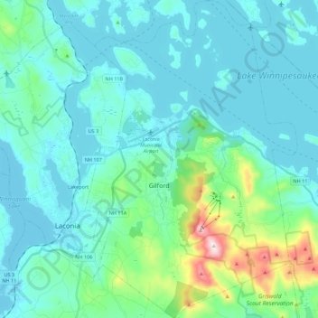
Naam: Topografische kaart Gilford, hoogte, reliëf.
Locatie: Gilford, Belknap County, New Hampshire, 03249, United States (43.48157 -71.45817 43.64057 -71.31150)
Gemiddelde hoogte: 231 m
Minimale hoogte: 146 m
Maximale hoogte: 720 m
According to the United States Census Bureau, the town has a total area of 53.6 square miles (138.7 km2), of which 38.8 sq mi (100.5 km2) are land and 14.7 sq mi (38.2 km2) are water, comprising 27.56% of the town. Belknap Mountain, elevation 2,384 feet (727 m) above sea level and the highest point in Gilford as well as Belknap County, is in the south. Much of the town is drained by the Gunstock River, a tributary of Lake Winnipesaukee. Gilford lies fully within the Merrimack River watershed.
Andere topografische kaarten
Klik op een kaart om zijn topografie, zijn hoogte en zijn reliëf te bekijken.
Lake Winnipesaukee
United States > New Hampshire > Belknap County > Alton
Lake Winnipesaukee, Alton, Belknap County, New Hampshire, 03226, United States
Gemiddelde hoogte: 223 m
The Plains
United States > New Hampshire > Belknap County > Tilton
The Plains, Tilton, Belknap County, New Hampshire, 03252, United States
Gemiddelde hoogte: 167 m
Mallard Cove
United States > New Hampshire > Belknap County > Laconia
Mallard Cove, Laconia, Belknap County, New Hampshire, 03246, United States
Gemiddelde hoogte: 173 m
Sanbornton
United States > New Hampshire > Belknap County
Sanbornton, Belknap County, New Hampshire, 03269, United States
Gemiddelde hoogte: 228 m
Tilton
United States > New Hampshire > Belknap County
Tilton, Belknap County, New Hampshire, United States
Gemiddelde hoogte: 196 m
Meredith
United States > New Hampshire > Belknap County
Meredith, Belknap County, New Hampshire, 03253, United States
Gemiddelde hoogte: 215 m
Barnstead
United States > New Hampshire > Belknap County
Barnstead, Belknap County, New Hampshire, United States
Gemiddelde hoogte: 221 m