
Topografische kaart Sanbornton
Interactieve kaart
Klik op de kaart om de hoogte weer te geven.
Over deze kaart
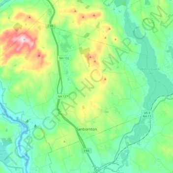
Naam: Topografische kaart Sanbornton, hoogte, reliëf.
Gemiddelde hoogte: 228 m
Minimale hoogte: 91 m
Maximale hoogte: 599 m
According to the United States Census Bureau, the town has a total area of 49.7 square miles (128.6 km2), of which 47.4 sq mi (122.7 km2) are land and 2.3 sq mi (5.9 km2) are water, comprising 4.58% of the town. Bounded on the west by the Pemigewasset River and on the east by Lake Winnisquam, Sanbornton is largely drained by Salmon Brook, a tributary of the Pemigewasset. The highest point in town is the summit of Hersey Mountain, elevation 2,001 feet (610 m) above sea level, along the town's northwestern border.
Andere topografische kaarten
Klik op een kaart om zijn topografie, zijn hoogte en zijn reliëf te bekijken.
Lake Winnipesaukee
United States > New Hampshire > Belknap County > Alton
Lake Winnipesaukee, Alton, Belknap County, New Hampshire, 03226, United States
Gemiddelde hoogte: 223 m
The Plains
United States > New Hampshire > Belknap County > Tilton
The Plains, Tilton, Belknap County, New Hampshire, 03252, United States
Gemiddelde hoogte: 167 m
Mallard Cove
United States > New Hampshire > Belknap County > Laconia
Mallard Cove, Laconia, Belknap County, New Hampshire, 03246, United States
Gemiddelde hoogte: 173 m
Gilford
United States > New Hampshire > Belknap County
Gilford, Belknap County, New Hampshire, 03249, United States
Gemiddelde hoogte: 231 m
Tilton
United States > New Hampshire > Belknap County
Tilton, Belknap County, New Hampshire, United States
Gemiddelde hoogte: 196 m
Meredith
United States > New Hampshire > Belknap County
Meredith, Belknap County, New Hampshire, 03253, United States
Gemiddelde hoogte: 215 m
Barnstead
United States > New Hampshire > Belknap County
Barnstead, Belknap County, New Hampshire, United States
Gemiddelde hoogte: 221 m