
Topografische kaart Mount Kinabalu
Interactieve kaart
Klik op de kaart om de hoogte weer te geven.
Over deze kaart
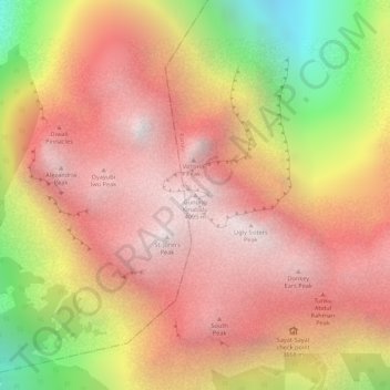
Naam: Topografische kaart Mount Kinabalu, hoogte, reliëf.
Locatie: Mount Kinabalu, Ranau, West Coast Division, Sabah, Malaysia (6.07502 116.55865 6.07512 116.55875)
Gemiddelde hoogte: 3.567 m
Minimale hoogte: 2.661 m
Maximale hoogte: 4.062 m
Mount Kinabalu (Malay: Gunung Kinabalu, Dusun: Gayo Ngaran or Nulu Nabalu) is the highest mountain in Borneo and Malaysia. With an elevation of 13,435 feet (4,095 m), it is third-highest peak of an island on Earth, and 20th most prominent mountain in the world by topographic prominence. The mountain is located in Ranau district, West Coast Division of Sabah, Malaysia. It is protected as Kinabalu Park, a World Heritage Site.
Andere topografische kaarten
Klik op een kaart om zijn topografie, zijn hoogte en zijn reliëf te bekijken.
Sungai Liwagu
Malaysia > Sabah > Ranau > Kampung Kimolohing
Sungai Liwagu, Pekan Ranau, Kampung Kimolohing, Ranau, West Coast Division, Sabah, 89300, Malaysia
Gemiddelde hoogte: 633 m
Timbua B (Kombiroi)
Timbua B (Kombiroi), Ranau, West Coast Division, Sabah, Malaysia
Gemiddelde hoogte: 200 m
Togudon Lama
Togudon Lama, Ranau, West Coast Division, Sabah, 89308, Malaysia
Gemiddelde hoogte: 1.073 m
Kinabalu Park
Malaysia > Sabah > Ranau > Tinompok
Kinabalu Park, Tinompok, Ranau, West Coast Division, Sabah, Malaysia
Gemiddelde hoogte: 2.063 m