
Topografische kaart Gaurikund
Interactieve kaart
Klik op de kaart om de hoogte weer te geven.
Over deze kaart
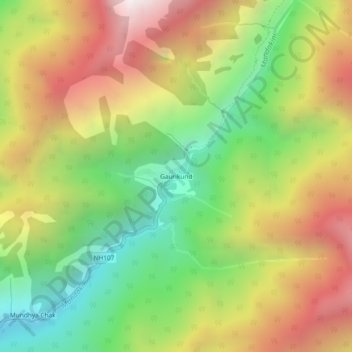
Naam: Topografische kaart Gaurikund, hoogte, reliëf.
Locatie: Gaurikund, Ukhimath, Rudraprayag, Uttarakhand, India (30.63340 79.00682 30.67340 79.04682)
Gemiddelde hoogte: 2.589 m
Minimale hoogte: 1.749 m
Maximale hoogte: 3.559 m
Andere topografische kaarten
Klik op een kaart om zijn topografie, zijn hoogte en zijn reliëf te bekijken.
Lake Vasuki Tal
India > Uttarakhand > Ukhimath > Kedarnath
Lake Vasuki Tal, Kedarnath, Ukhimath, Rudraprayag District, Uttarakhand, India
Gemiddelde hoogte: 4.303 m
Chorabari Glacier
India > Uttarakhand > Ukhimath > Kedarnath
Chorabari Glacier, Kedarnath, Ukhimath, Rudraprayag District, Uttarakhand, India
Gemiddelde hoogte: 5.011 m
Mansuna
India > Uttarakhand > Ukhimath
Mansuna, Ukhimath, Rudraprayag District, Uttarakhand, 246469, India
Gemiddelde hoogte: 1.653 m
Uthind
India > Uttarakhand > Ukhimath
Uthind, Ukhimath, Rudraprayag District, Uttarakhand, 246419, India
Gemiddelde hoogte: 1.601 m
Khunnu
India > Uttarakhand > Ukhimath
Khunnu, Ukhimath, Rudraprayag District, Uttarakhand, India
Gemiddelde hoogte: 1.841 m
Kedarnath
India > Uttarakhand > Ukhimath
Kedarnath, Ukhimath, Rudraprayag District, Uttarakhand, India
Gemiddelde hoogte: 4.219 m
Chopta Chatti
India > Uttarakhand > Ukhimath > Chopta Chatti
Chopta Chatti, Ukhimath, Rudraprayag, Uttarakhand, India
Gemiddelde hoogte: 2.759 m
Sersi
India > Uttarakhand > Ukhimath > Sersi
Sersi, Ukhimath, Rudraprayag, Uttarakhand, 246471, India
Gemiddelde hoogte: 1.942 m
Sonprayag
India > Uttarakhand > Ukhimath
Sonprayag, Ukhimath, Rudraprayag, Uttarakhand, 246471, India
Gemiddelde hoogte: 2.053 m
Guptkashi
India > Uttarakhand > Ukhimath
Guptkashi, Ukhimath, Rudraprayag District, Uttarakhand, 246439, India
Gemiddelde hoogte: 1.449 m