
Topografische kaart Randle
Klik op de kaart om de hoogte weer te geven.
Over deze kaart
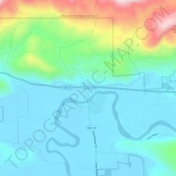
Naam: Topografische kaart Randle, hoogte, reliëf.
Locatie: Randle, Lewis County, Washington, United States (46.51511 -121.97704 46.55511 -121.93704)
Gemiddelde hoogte: 378 m
Minimale hoogte: 260 m
Maximale hoogte: 770 m
Andere topografische kaarten
Klik op een kaart om zijn topografie, zijn hoogte en zijn reliëf te bekijken.
Winlock
United States > Washington > Lewis County
The eastern edge of the Willapa Hills lie to the west. To the east are relatively flat prairies. A notable landmark about four miles west of town is Sam Henry Mountain, elevation 1,492 feet (455 m), named for an early section superintendent of the Northern Pacific Railroad. Mt. St. Helens, about forty miles…
Gemiddelde hoogte: 124 m