
Topografische kaart Crystal
Interactieve kaart
Klik op de kaart om de hoogte weer te geven.
Over deze kaart
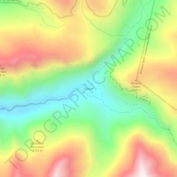
Naam: Topografische kaart Crystal, hoogte, reliëf.
Locatie: Crystal, Gunnison County, Colorado, United States (39.03916 -107.12116 39.07916 -107.08116)
Gemiddelde hoogte: 3.146 m
Minimale hoogte: 2.672 m
Maximale hoogte: 3.712 m
The elevation of Crystal is centered at 8,950 ft, however the area in and around crystal ranges from 8,500 ft to peaks of 13,500 ft. The land is well drained, and the rock types such as limestone create very steep slopes common in the Rocky Mountains. The area is described as having classically alpine terrain in characteristics, and the sources of the areas streams are mainly glacial cirques. Barren parts of the mountains that are at elevations low enough to support vegetation growth are primarily unable to support much vegetation due to the steep slopes and the large accumulation of shale rocks.
Andere topografische kaarten
Klik op een kaart om zijn topografie, zijn hoogte en zijn reliëf te bekijken.
Almont
United States > Colorado > Gunnison County
Almont, Gunnison County, Colorado, 81210, United States
Gemiddelde hoogte: 2.578 m
Gothic Mountain
United States > Colorado > Gunnison County
Gothic Mountain, Gunnison County, Colorado, United States
Gemiddelde hoogte: 3.297 m
Whitepine
United States > Colorado > Gunnison County
Whitepine, Gunnison County, Colorado, United States
Gemiddelde hoogte: 3.202 m
Buck Mesa
United States > Colorado > Gunnison County
Buck Mesa, Gunnison County, Colorado, United States
Gemiddelde hoogte: 2.846 m
Crested Butte
United States > Colorado > Gunnison County
Crested Butte, Gunnison County, Colorado, 81224, United States
Gemiddelde hoogte: 2.798 m
Marble
United States > Colorado > Gunnison County
Marble, Gunnison County, Colorado, United States
Gemiddelde hoogte: 2.611 m
Copper Mountain
United States > Colorado > Gunnison County
Copper Mountain, Gunnison County, Colorado, 81241, United States
Gemiddelde hoogte: 3.073 m
Floresta
United States > Colorado > Gunnison County
Floresta, Gunnison County, Colorado, United States
Gemiddelde hoogte: 3.110 m
Granite Basin
United States > Colorado > Gunnison County
Granite Basin, Gunnison County, Colorado, United States
Gemiddelde hoogte: 3.203 m
Gunnison
United States > Colorado > Gunnison County
Gunnison, Gunnison County, Colorado, United States
Gemiddelde hoogte: 2.369 m
Tincup
United States > Colorado > Gunnison County > Tincup
Tincup, Gunnison County, Colorado, United States
Gemiddelde hoogte: 3.220 m
Sapinero
United States > Colorado > Gunnison County
Sapinero, Gunnison County, Colorado, 81247, United States
Gemiddelde hoogte: 2.340 m