
Topografische kaart Greer County
Interactieve kaart
Klik op de kaart om de hoogte weer te geven.
Over deze kaart
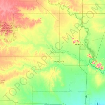
Naam: Topografische kaart Greer County, hoogte, reliëf.
Locatie: Greer County, Oklahoma, United States of America (34.72463 -99.88827 35.11698 -99.24667)
Gemiddelde hoogte: 504 m
Minimale hoogte: 411 m
Maximale hoogte: 705 m
Andere topografische kaarten
Klik op een kaart om zijn topografie, zijn hoogte en zijn reliëf te bekijken.
Skiatook Lake
United States of America > Oklahoma > Morgans Corner
Skiatook Lake, Major General Clarence L. Tinker Memorial Highway, Morgans Corner, Osage County, Oklahoma, United States of America
Gemiddelde hoogte: 228 m
Porum
United States of America > Oklahoma > Porum
Porum, Muskogee County, Oklahoma, 74455, United States of America
Gemiddelde hoogte: 181 m
Idabel
United States of America > Oklahoma > Idabel
Idabel, McCurtain County, Oklahoma, 74745, United States of America
Gemiddelde hoogte: 132 m
Woodall
United States of America > Oklahoma
Woodall, Cherokee County, Oklahoma, United States of America
Gemiddelde hoogte: 232 m
Guymon
United States of America > Oklahoma > Guymon
Guymon, Texas, Oklahoma, United States of America
Gemiddelde hoogte: 933 m
Coalgate
United States of America > Oklahoma > Coalgate
Coalgate, Coal County, Oklahoma, 74538, United States of America
Gemiddelde hoogte: 186 m
Foss
United States of America > Oklahoma > Foss
Foss, Washita County, Oklahoma, United States of America
Gemiddelde hoogte: 508 m
Wynnewood
United States of America > Oklahoma > Wynnewood
Wynnewood, Oklahoma, 73098, United States of America
Gemiddelde hoogte: 271 m
Bethany
United States of America > Oklahoma > Bethany
Bethany, Oklahoma County, Oklahoma, United States of America
Gemiddelde hoogte: 396 m