
Topografische kaart La Muralla
Interactieve kaart
Klik op de kaart om de hoogte weer te geven.
Over deze kaart
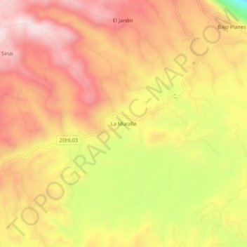
Naam: Topografische kaart La Muralla, hoogte, reliëf.
Gemiddelde hoogte: 1.714 m
Minimale hoogte: 1.367 m
Maximale hoogte: 1.928 m
Andere topografische kaarten
Klik op een kaart om zijn topografie, zijn hoogte en zijn reliëf te bekijken.
Isnos Huila
Isnos Huila, Isnos, Sur, Huila, RAP (Especial) Central, Colombia
Gemiddelde hoogte: 1.782 m
El Mortiño
El Mortiño, Isnos, Sur, Huila, RAP (Especial) Central, 418060, Colombia
Gemiddelde hoogte: 1.591 m
Parque Nacional Natural Puracé
Parque Nacional Natural Puracé, Isnos, Sur, Huila, RAP (Especial) Central, Colombia
Gemiddelde hoogte: 2.708 m
Paloquemao
Paloquemao, Isnos, Sur, Huila, RAP (Especial) Central, Colombia
Gemiddelde hoogte: 2.152 m