
Topografische kaart Tczew
Interactieve kaart
Klik op de kaart om de hoogte weer te geven.
Over deze kaart
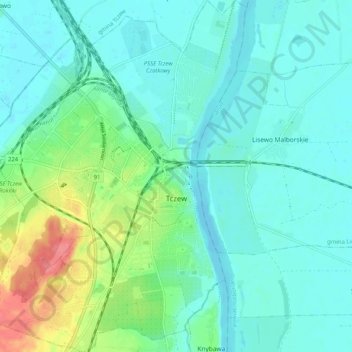
Naam: Topografische kaart Tczew, hoogte, reliëf.
Locatie: Tczew, Tczew County, Pomeranian Voivodeship, 83-110, Poland (54.06077 18.74264 54.12066 18.82058)
Gemiddelde hoogte: 16 m
Minimale hoogte: -2 m
Maximale hoogte: 72 m
Andere topografische kaarten
Klik op een kaart om zijn topografie, zijn hoogte en zijn reliëf te bekijken.
Gniew
Poland > Pomeranian Voivodeship > Tczew County
Gniew, gmina Gniew, Tczew County, Pomeranian Voivodeship, 83-140, Poland
Gemiddelde hoogte: 33 m
Opalenie
Poland > Pomeranian Voivodeship > Tczew County
Opalenie, gmina Gniew, Tczew County, Pomeranian Voivodeship, 83-136, Poland
Gemiddelde hoogte: 35 m
Turze
Poland > Pomeranian Voivodeship > Tczew County
Turze, gmina Tczew, Tczew County, Pomeranian Voivodeship, Poland
Gemiddelde hoogte: 73 m
Tczew
Poland > Pomeranian Voivodeship > Tczew County > Tczew
Tczew, Tczew County, Pomeranian Voivodeship, 83-110, Poland
Gemiddelde hoogte: 21 m