
Topografische kaart Gniew
Interactieve kaart
Klik op de kaart om de hoogte weer te geven.
Over deze kaart
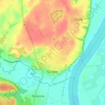
Naam: Topografische kaart Gniew, hoogte, reliëf.
Gemiddelde hoogte: 33 m
Minimale hoogte: 6 m
Maximale hoogte: 70 m
Andere topografische kaarten
Klik op een kaart om zijn topografie, zijn hoogte en zijn reliëf te bekijken.
Tczew
Poland > Pomeranian Voivodeship > Tczew County
Tczew, Tczew County, Pomeranian Voivodeship, 83-110, Poland
Gemiddelde hoogte: 16 m
Opalenie
Poland > Pomeranian Voivodeship > Tczew County
Opalenie, gmina Gniew, Tczew County, Pomeranian Voivodeship, 83-136, Poland
Gemiddelde hoogte: 35 m
Turze
Poland > Pomeranian Voivodeship > Tczew County
Turze, gmina Tczew, Tczew County, Pomeranian Voivodeship, Poland
Gemiddelde hoogte: 73 m
Tczew
Poland > Pomeranian Voivodeship > Tczew County > Tczew
Tczew, Tczew County, Pomeranian Voivodeship, 83-110, Poland
Gemiddelde hoogte: 21 m