
Topografische kaart McClure
Interactieve kaart
Klik op de kaart om de hoogte weer te geven.
Over deze kaart
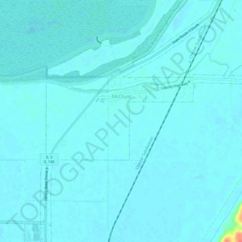
Naam: Topografische kaart McClure, hoogte, reliëf.
Locatie: McClure, Alexander County, Illinois, United States (37.29204 -89.44949 37.33476 -89.39585)
Gemiddelde hoogte: 103 m
Minimale hoogte: 98 m
Maximale hoogte: 150 m
Andere topografische kaarten
Klik op een kaart om zijn topografie, zijn hoogte en zijn reliëf te bekijken.
Cairo
United States > Illinois > Alexander County
Cairo, Alexander County, Illinois, 62914, United States
Gemiddelde hoogte: 95 m
Cairo
United States > Illinois > Alexander County > Cairo > Cairo
Cairo, Alexander County, Illinois, 62914, United States
Gemiddelde hoogte: 95 m
Dogtooth Bend Mounds
United States > Illinois > Alexander County
Dogtooth Bend Mounds, Alexander County, Illinois, 62962, United States
Gemiddelde hoogte: 98 m
Big Cypress
United States > Illinois > Alexander County
Big Cypress, Alexander County, Illinois, 62969, United States
Gemiddelde hoogte: 101 m
Thebes
United States > Illinois > Alexander County
Thebes, Alexander County, Illinois, 62990, United States
Gemiddelde hoogte: 119 m