
Topografische kaart Mount Redoubt
Klik op de kaart om de hoogte weer te geven.
Mount Redoubt
The North Cascades features some of the most rugged topography in the Cascade Range with craggy peaks, spires, ridges, and deep glacial valleys. Geological events occurring many years ago created the diverse topography and drastic elevation changes over the Cascade Range leading to the various climate differences.
Over deze kaart
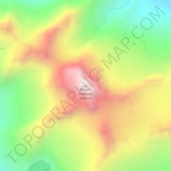
Naam: Topografische kaart Mount Redoubt, hoogte, reliëf.
Locatie: Mount Redoubt, Whatcom County, Washington, United States (48.95778 -121.30083 48.95788 -121.30073)
Gemiddelde hoogte: 2.070 m
Minimale hoogte: 1.488 m
Maximale hoogte: 2.710 m
Andere topografische kaarten
Klik op een kaart om zijn topografie, zijn hoogte en zijn reliëf te bekijken.
Bellingham
United States > Washington > Whatcom County
Bellingham is characterized by a diverse and striking topography that combines coastal and mountainous landscapes. The city lies along the eastern shore of Bellingham Bay, where the waters of the Puget Sound meet the foothills of the Cascade Range. Rising abruptly from the shoreline, the surrounding hills and…
Gemiddelde hoogte: 89 m
North Cascades National Park
United States > Washington > Whatcom County
More than 500 lakes and ponds are located within North Cascades National Park. Many of these are devoid of fish, not uncommon in steep terrain where fish may not be able to access high altitude waterways. Around 240 of these lakes exist in the higher elevations and stocking of some of these lakes with fish has…
Gemiddelde hoogte: 1.150 m
Bellingham
United States > Washington > Whatcom County
According to the United States Census Bureau, the city has a total area of 28.90 square miles (74.85 km2), of which, 27.08 square miles (70.14 km2) is land and 1.82 square miles (4.71 km2) is water. The lowest elevations are at sea level along the waterfront. Alabama Hill is one of the higher points in the…
Gemiddelde hoogte: 89 m
Diablo Lake
United States > Washington > Whatcom County
Diablo Lake is a reservoir in the North Cascade mountains of northern Washington state, United States. Created by Diablo Dam, the lake is located between Ross Lake and Gorge Lake on the Skagit River at an elevation of 1,201 feet (366 m) above sea level. Diablo Lake is part of the Skagit River Hydroelectric…
Gemiddelde hoogte: 643 m
Bellingham
United States > Washington > Whatcom County
According to the United States Census Bureau, the city has a total area of 30.511 square miles (79.02 km2), of which, 28.198 square miles (73.03 km2) is land and 2.313 square miles (5.99 km2) is water. The lowest elevations are at sea level along the waterfront. Alabama Hill is one of the higher points in the…
Gemiddelde hoogte: 89 m
Ross Lake
United States > Washington > Whatcom County
Ross Lake is a large reservoir in the North Cascade mountains of northern Washington state, United States, and southwestern British Columbia, Canada. The lake runs approximately north–south, is 23 miles (37 km) long, up to 1.5 miles (2.5 km) wide, and the full reservoir elevation is 1,604 feet above sea…
Gemiddelde hoogte: 1.314 m
Bellingham
United States > Washington > Whatcom County
According to the United States Census Bureau, the city has a total area of 30.511 square miles (79.02 km2), of which, 28.198 square miles (73.03 km2) is land and 2.313 square miles (5.99 km2) is water. The lowest elevations are at sea level along the waterfront. Alabama Hill is one of the higher points in the…
Gemiddelde hoogte: 89 m