
Doe een donatie
Rust jezelf uit voor je volgende avontuur:
Als Amazon-partner verdient deze site een commissie op in aanmerking komende aankopen, zonder extra kosten voor jou.
Topografische kaart Lummi Island
Klik op de kaart om de hoogte weer te geven.
Doe een donatie
Rust jezelf uit voor je volgende avontuur:
Als Amazon-partner verdient deze site een commissie op in aanmerking komende aankopen, zonder extra kosten voor jou.
Over deze kaart
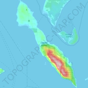
Naam: Topografische kaart Lummi Island, hoogte, reliëf.
Locatie: Lummi Island, Whatcom County, Washington, United States (48.64030 -122.72234 48.74885 -122.60833)
Gemiddelde hoogte: 24 m
Minimale hoogte: -1 m
Maximale hoogte: 510 m
Doe een donatie
Rust jezelf uit voor je volgende avontuur:
Als Amazon-partner verdient deze site een commissie op in aanmerking komende aankopen, zonder extra kosten voor jou.
Andere topografische kaarten
Klik op een kaart om zijn topografie, zijn hoogte en zijn reliëf te bekijken.
Doe een donatie
Rust jezelf uit voor je volgende avontuur:
Als Amazon-partner verdient deze site een commissie op in aanmerking komende aankopen, zonder extra kosten voor jou.
Doe een donatie
Rust jezelf uit voor je volgende avontuur:
Als Amazon-partner verdient deze site een commissie op in aanmerking komende aankopen, zonder extra kosten voor jou.
Ruby Mountain
United States > Washington > Whatcom County
Ruby Mountain is a prominent 7,412-foot (2,259-metre) mountain summit located in the North Cascades Range of Washington state. It is situated in Ross Lake National Recreation Area which is part of the North Cascades National Park Complex. The Diablo Lake Overlook along the North Cascades Highway is at the foot…
Gemiddelde hoogte: 1.731 m
Doe een donatie
Rust jezelf uit voor je volgende avontuur:
Als Amazon-partner verdient deze site een commissie op in aanmerking komende aankopen, zonder extra kosten voor jou.
Mount Redoubt
United States > Washington > Whatcom County
The North Cascades features some of the most rugged topography in the Cascade Range with craggy peaks, spires, ridges, and deep glacial valleys. Geological events occurring many years ago created the diverse topography and drastic elevation changes over the Cascade Range leading to the various climate…
Gemiddelde hoogte: 2.070 m
Doe een donatie
Rust jezelf uit voor je volgende avontuur:
Als Amazon-partner verdient deze site een commissie op in aanmerking komende aankopen, zonder extra kosten voor jou.
Doe een donatie
Rust jezelf uit voor je volgende avontuur:
Als Amazon-partner verdient deze site een commissie op in aanmerking komende aankopen, zonder extra kosten voor jou.
Bellingham
United States > Washington > Whatcom County > Bellingham
According to the United States Census Bureau, the city has a total area of 28.90 square miles (74.85 km2), of which, 27.08 square miles (70.14 km2) is land and 1.82 square miles (4.71 km2) is water. The lowest elevations are at sea level along the waterfront. Alabama Hill is one of the higher points in the…
Gemiddelde hoogte: 129 m