
Topografische kaart Darcha
Interactieve kaart
Klik op de kaart om de hoogte weer te geven.
Over deze kaart
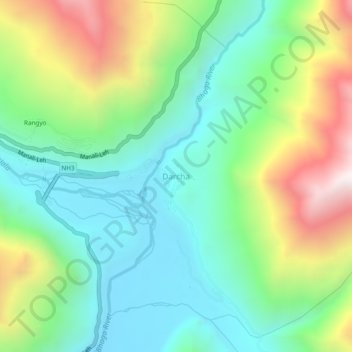
Naam: Topografische kaart Darcha, hoogte, reliëf.
Gemiddelde hoogte: 3.702 m
Minimale hoogte: 3.284 m
Maximale hoogte: 4.563 m
Darcha also known as Dartse (elevation 3,360 m or 11,020 ft) is a pair of villages (Darcha Sumdo and Darach Dangma) on the Bhaga River in the Lahaul sub-division in the Lahaul and Spiti district in the Indian state of Himachal Pradesh. It is the northernmost permanent settlement in Himachal Pradesh along the Manali-Leh Highway. With the opening of the Atal Tunnel, Darcha is likely to see a large influx of tourists as it is now connected to Manali throughout the year. The Nimmu–Padam–Darcha road which is being constructed, will improve connectivity of Kargil, Zanskar and Leh District of Ladakh to Darcha.
Andere topografische kaarten
Klik op een kaart om zijn topografie, zijn hoogte en zijn reliëf te bekijken.
Chandratal Lake
India > Himachal Pradesh > Lahul
Chandratal Lake, Lahul, Lahaul and Spiti District, Himachal Pradesh, India
Gemiddelde hoogte: 4.403 m
Sarchu
India > Himachal Pradesh > Lahul
Sarchu, Lahul, Lahul and Spiti, Himachal Pradesh, India
Gemiddelde hoogte: 5.408 m
Teling
India > Himachal Pradesh > Lahul
Teling, Lahul, Lahul and Spiti, Himachal Pradesh, India
Gemiddelde hoogte: 3.527 m
Koksar
India > Himachal Pradesh > Lahul
Koksar, Lahul, Lahul and Spiti, Himachal Pradesh, India
Gemiddelde hoogte: 3.634 m
Sissu
India > Himachal Pradesh > Lahul > Sissu
Sissu, Lahul, Lahul and Spiti, Himachal Pradesh, India
Gemiddelde hoogte: 4.343 m
Chikka
India > Himachal Pradesh > Lahul
Chikka, Lahul, Lahaul and Spiti District, Himachal Pradesh, India
Gemiddelde hoogte: 4.094 m
Rohtang Pass
India > Himachal Pradesh > Lahul
Rohtang Pass, Lahul, Lahul and Spiti, Himachal Pradesh, India
Gemiddelde hoogte: 4.042 m
Sissu
India > Himachal Pradesh > Lahul
Sissu, Lahul, Lahaul and Spiti District, Himachal Pradesh, India
Gemiddelde hoogte: 3.404 m