
Topografische kaart Sissu
Interactieve kaart
Klik op de kaart om de hoogte weer te geven.
Over deze kaart
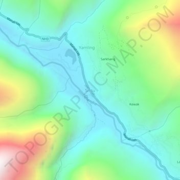
Naam: Topografische kaart Sissu, hoogte, reliëf.
Gemiddelde hoogte: 3.404 m
Minimale hoogte: 2.983 m
Maximale hoogte: 4.489 m
Andere topografische kaarten
Klik op een kaart om zijn topografie, zijn hoogte en zijn reliëf te bekijken.
Chandratal Lake
India > Himachal Pradesh > Lahul
Chandratal Lake, Lahul, Lahaul and Spiti District, Himachal Pradesh, India
Gemiddelde hoogte: 4.403 m
Sarchu
India > Himachal Pradesh > Lahul
Sarchu, Lahul, Lahul and Spiti, Himachal Pradesh, India
Gemiddelde hoogte: 5.408 m
Teling
India > Himachal Pradesh > Lahul
Teling, Lahul, Lahul and Spiti, Himachal Pradesh, India
Gemiddelde hoogte: 3.527 m
Koksar
India > Himachal Pradesh > Lahul
Koksar, Lahul, Lahul and Spiti, Himachal Pradesh, India
Gemiddelde hoogte: 3.634 m
Sissu
India > Himachal Pradesh > Lahul > Sissu
Sissu, Lahul, Lahul and Spiti, Himachal Pradesh, India
Gemiddelde hoogte: 4.343 m
Chikka
India > Himachal Pradesh > Lahul
Chikka, Lahul, Lahaul and Spiti District, Himachal Pradesh, India
Gemiddelde hoogte: 4.094 m
Rohtang Pass
India > Himachal Pradesh > Lahul
Rohtang Pass, Lahul, Lahul and Spiti, Himachal Pradesh, India
Gemiddelde hoogte: 4.042 m
Darcha
India > Himachal Pradesh > Lahul
Darcha, Lahul, Lahaul and Spiti District, Himachal Pradesh, India
Gemiddelde hoogte: 3.702 m