
Topografische kaart Fort Sill
Interactieve kaart
Klik op de kaart om de hoogte weer te geven.
Over deze kaart
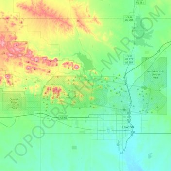
Naam: Topografische kaart Fort Sill, hoogte, reliëf.
Locatie: Fort Sill, Comanche County, Oklahoma, United States (34.63753 -98.75591 34.76803 -98.28239)
Gemiddelde hoogte: 417 m
Minimale hoogte: 314 m
Maximale hoogte: 749 m
Andere topografische kaarten
Klik op een kaart om zijn topografie, zijn hoogte en zijn reliëf te bekijken.
Daly Hill
United States > Oklahoma > Comanche County
Daly Hill, Comanche County, Oklahoma, United States
Gemiddelde hoogte: 396 m
Jackson Hole
United States > Oklahoma > Comanche County
Jackson Hole, Comanche County, Oklahoma, United States
Gemiddelde hoogte: 406 m
South East Corner Landing Strip
United States > Oklahoma > Comanche County
South East Corner Landing Strip, Comanche County, Oklahoma, United States
Gemiddelde hoogte: 383 m
Mount McKinley
United States > Oklahoma > Comanche County
Mount McKinley, Comanche County, Oklahoma, United States
Gemiddelde hoogte: 498 m
Medicine Park
United States > Oklahoma > Comanche County > Medicine Park
Medicine Park, Comanche County, Oklahoma, 73557, United States
Gemiddelde hoogte: 429 m
Lawton
United States > Oklahoma > Comanche County
Lawton, Comanche County, Oklahoma, United States
Gemiddelde hoogte: 352 m