
Topografische kaart Lawton
Interactieve kaart
Klik op de kaart om de hoogte weer te geven.
Over deze kaart
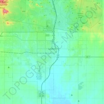
Naam: Topografische kaart Lawton, hoogte, reliëf.
Locatie: Lawton, Comanche County, Oklahoma, United States (34.51150 -98.53649 34.69435 -98.31443)
Gemiddelde hoogte: 352 m
Minimale hoogte: 314 m
Maximale hoogte: 525 m
Developed on former reservation lands of the Kiowa, Comanche, and Apache Indians, Lawton was founded by European Americans on 6 August 1901. It was named after Major General Henry Ware Lawton, who served in the Civil War, where he earned the Medal of Honor, and was killed in action in the Philippine–American War. Lawton's landscape is typical of the Great Plains, with flat topography and gently rolling hills, while the area north of the city is marked by the Wichita Mountains.
Andere topografische kaarten
Klik op een kaart om zijn topografie, zijn hoogte en zijn reliëf te bekijken.
Daly Hill
United States > Oklahoma > Comanche County
Daly Hill, Comanche County, Oklahoma, United States
Gemiddelde hoogte: 396 m
Jackson Hole
United States > Oklahoma > Comanche County
Jackson Hole, Comanche County, Oklahoma, United States
Gemiddelde hoogte: 406 m
South East Corner Landing Strip
United States > Oklahoma > Comanche County
South East Corner Landing Strip, Comanche County, Oklahoma, United States
Gemiddelde hoogte: 383 m
Mount McKinley
United States > Oklahoma > Comanche County
Mount McKinley, Comanche County, Oklahoma, United States
Gemiddelde hoogte: 498 m
Fort Sill
United States > Oklahoma > Comanche County
Fort Sill, Comanche County, Oklahoma, United States
Gemiddelde hoogte: 417 m
Medicine Park
United States > Oklahoma > Comanche County > Medicine Park
Medicine Park, Comanche County, Oklahoma, 73557, United States
Gemiddelde hoogte: 429 m