
Topografische kaart Aeneas
Klik op de kaart om de hoogte weer te geven.
Over deze kaart
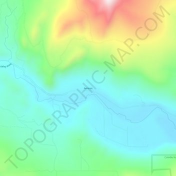
Naam: Topografische kaart Aeneas, hoogte, reliëf.
Locatie: Aeneas, Okanogan County, Washington, United States (48.52738 -118.99864 48.56738 -118.95864)
Gemiddelde hoogte: 897 m
Minimale hoogte: 719 m
Maximale hoogte: 1.343 m
Andere topografische kaarten
Klik op een kaart om zijn topografie, zijn hoogte en zijn reliëf te bekijken.
Tonasket
United States > Washington > Okanogan County
Tonasket is located at 48°42′20″N 119°26′19″W / 48.70556°N 119.43861°W / 48.70556; -119.43861 (48.705626, -119.438568). at an altitude of 1,311 ft (400 m).
Gemiddelde hoogte: 342 m
Winthrop
United States > Washington > Okanogan County
Winthrop lies at the confluence of the Methow and Chewuch rivers in the Methow Valley. The town is in the eastern foothills of the Cascade Mountains at an elevation of 1,760 feet (540 m). The Okanogan–Wenatchee National Forest and state-managed Methow Wildlife Area surround the Methow Valley.
Gemiddelde hoogte: 567 m
Omak
United States > Washington > Okanogan County
Elevations around the area range from 780 feet (240 m) above sea level at the mouth of the Okanogan River to 6,774 feet (2,065 m) above sea level at the Moses Mountain. The average elevation is 843 feet (257 m) above sea level according to the United States Geological Survey (USGS). The Moses Mountain, with a…
Gemiddelde hoogte: 364 m
Grand Coulee Dam
United States > Washington > Okanogan County
After power shortages in the Northwest during the 1960s, it was determined the six remaining planned pumps be pump-generators. When energy demand is high, the pump-generators can generate electricity with water from the Banks Lake feeder canal adjacent to the dam at a higher elevation. By 1973, the…
Gemiddelde hoogte: 423 m
Tonasket
United States > Washington > Okanogan County
Tonasket is located along the Okanogan River at an altitude of 1,311 ft (400 m).
Gemiddelde hoogte: 347 m
Tonasket
United States > Washington > Okanogan County
Tonasket is located along the Okanogan River at an altitude of 1,311 ft (400 m).
Gemiddelde hoogte: 342 m