
Topografische kaart Wilsons Promontory National Park
Interactieve kaart
Klik op de kaart om de hoogte weer te geven.
Over deze kaart
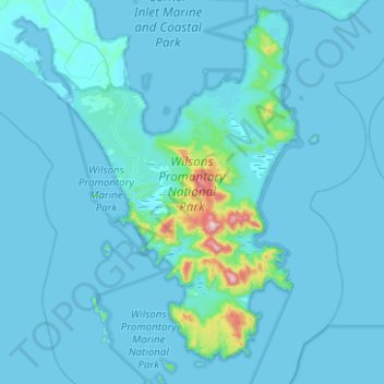
Naam: Topografische kaart Wilsons Promontory National Park, hoogte, reliëf.
Locatie: Wilsons Promontory National Park, Victoria, Australia (-39.15919 146.17037 -38.77096 146.51399)
Gemiddelde hoogte: 32 m
Minimale hoogte: -1 m
Maximale hoogte: 734 m
Andere topografische kaarten
Klik op een kaart om zijn topografie, zijn hoogte en zijn reliëf te bekijken.
Dandenong Ranges National Park - Ferntree Gully
Australia > Victoria > Montrose
Dandenong Ranges National Park - Ferntree Gully, Rollings Road, Upper Ferntree Gully, City of Knox, Victoria, 3785, Australia
Gemiddelde hoogte: 345 m
Eltham District
Australia > Victoria > Greensborough
Eltham District, Greensborough, City of Banyule, Victoria, Australia
Gemiddelde hoogte: 85 m
Phillip Island
Australia > Victoria > Ventnor
Phillip Island, Ventnor, Bass Coast Shire, Victoria, Australia
Gemiddelde hoogte: 5 m
Yarra Ranges National Park
Australia > Victoria > Melbourne
Yarra Ranges National Park, Reefton, Melbourne, Shire of Yarra Ranges, Victoria, Australia
Gemiddelde hoogte: 465 m
Little Desert
Little Desert, Shire of Hindmarsh, Victoria, 3418, Australia
Gemiddelde hoogte: 146 m
Mornington District
Australia > Victoria > Melbourne
Mornington District, Melbourne, Shire of Mornington Peninsula, Victoria, Australia
Gemiddelde hoogte: 50 m
Elwood Beach
Australia > Victoria > Melbourne
Elwood Beach, Elwood, Melbourne, City of Port Phillip, Victoria, Australia
Gemiddelde hoogte: 6 m
Whitby Reserve
Australia > Victoria > Melbourne
Whitby Reserve, Reservoir, Melbourne, City of Darebin, Victoria, Australia
Gemiddelde hoogte: 90 m
Castlemaine
Castlemaine, Shire of Mount Alexander, Victoria, 3450, Australia
Gemiddelde hoogte: 319 m
Lake Glenmaggie
Lake Glenmaggie, Glenmaggie, Shire of Wellington, Victoria, Australia
Gemiddelde hoogte: 98 m
Mount Eliza
Australia > Victoria > Melbourne
Mount Eliza, Melbourne, Shire of Mornington Peninsula, Victoria, 3930, Australia
Gemiddelde hoogte: 60 m
Melbourne District
Australia > Victoria > Melbourne
Melbourne District, Melbourne, City of Melbourne, Victoria, Australia
Gemiddelde hoogte: 20 m
Garfield North
Australia > Victoria > Melbourne
Garfield North, Melbourne, Shire of Cardinia, Victoria, 3814, Australia
Gemiddelde hoogte: 137 m
Mount Martha
Australia > Victoria > Melbourne
Mount Martha, Melbourne, Shire of Mornington Peninsula, Victoria, 3934, Australia
Gemiddelde hoogte: 40 m
Ocean Grove
Australia > Victoria > Ocean Grove
Ocean Grove, City of Greater Geelong, Victoria, 3226, Australia
Gemiddelde hoogte: 16 m
Warrnambool
Warrnambool, City of Warrnambool, Victoria, 3280, Australia
Gemiddelde hoogte: 19 m
North Wangaratta
North Wangaratta, Rural City of Wangaratta, Victoria, 3678, Australia
Gemiddelde hoogte: 148 m
Division of Kooyong
Australia > Victoria > Melbourne
Division of Kooyong, Melbourne, City of Boroondara, Victoria, Australia
Gemiddelde hoogte: 55 m
Grampians National Park
Grampians National Park, Bellfield, Shire of Northern Grampians, Victoria, Australia
Gemiddelde hoogte: 262 m
Shepparton District
Australia > Victoria > Shepparton
Shepparton District, Currawa Rise, Dookie, Shepparton, City of Greater Shepparton, Hume, Victoria, 3630, Australia
Gemiddelde hoogte: 113 m
Great Otway National Park
Great Otway National Park, Victoria, Australia
Gemiddelde hoogte: 91 m
Glen Waverley
Glen Waverley, City of Monash, Victoria, 3150, Australia
Gemiddelde hoogte: 103 m
Yarra Valley
Australia > Victoria > Melbourne
Yarra Valley, Melbourne, Shire of Yarra Ranges, Victoria, Australia
Gemiddelde hoogte: 305 m