
Topografische kaart Black River-Matheson Township
Interactieve kaart
Klik op de kaart om de hoogte weer te geven.
Over deze kaart
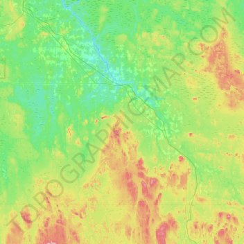
Naam: Topografische kaart Black River-Matheson Township, hoogte, reliëf.
Gemiddelde hoogte: 306 m
Minimale hoogte: 248 m
Maximale hoogte: 447 m
Andere topografische kaarten
Klik op een kaart om zijn topografie, zijn hoogte en zijn reliëf te bekijken.
Kapuskasing
Canada > Ontario > Cochrane District
Kapuskasing, Cochrane District, Northeastern Ontario, Ontario, Canada
Gemiddelde hoogte: 227 m
Unorganized North Cochrane
Canada > Ontario > Cochrane District
Unorganized North Cochrane, Cochrane District, Northeastern Ontario, Ontario, P0L 1W0, Canada
Gemiddelde hoogte: 195 m
Moose River
Canada > Ontario > Cochrane District
Moose River, Cochrane District, Northeastern Ontario, Ontario, P0L 1Y0, Canada
Gemiddelde hoogte: 36 m
Cochrane
Canada > Ontario > Cochrane District > Cochrane
Cochrane, Cochrane District, Northeastern Ontario, Ontario, P0L 1C0, Canada
Gemiddelde hoogte: 262 m
Iroquois Falls
Canada > Ontario > Cochrane District
Iroquois Falls, Cochrane District, Northeastern Ontario, Ontario, Canada
Gemiddelde hoogte: 281 m
Moosonee
Canada > Ontario > Cochrane District > Moosonee
Moosonee, Cochrane District, Northeastern Ontario, Ontario, P0L 1Y0, Canada
Gemiddelde hoogte: 7 m
Driftwood
Canada > Ontario > Cochrane District > Unorganized North Cochrane > Driftwood
Driftwood, Unorganized North Cochrane, Cochrane District, Northeastern Ontario, Ontario, Canada
Gemiddelde hoogte: 272 m
Whitepine Hill
Canada > Ontario > Cochrane District > Timmins
Whitepine Hill, Timmins, Cochrane District, Northeastern Ontario, Ontario, Canada
Gemiddelde hoogte: 293 m
Moose Factory
Canada > Ontario > Cochrane District
Moose Factory, Cochrane District, Northeastern Ontario, Ontario, P0L 1W0, Canada
Gemiddelde hoogte: 5 m
Timmins
Canada > Ontario > Cochrane District
Timmins, Cochrane District, Northeastern Ontario, Ontario, Canada
Gemiddelde hoogte: 302 m