
Topografische kaart Worland
Interactieve kaart
Klik op de kaart om de hoogte weer te geven.
Over deze kaart
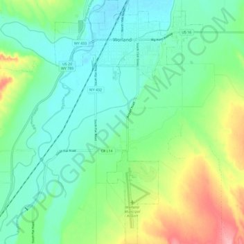
Naam: Topografische kaart Worland, hoogte, reliëf.
Locatie: Worland, Washakie County, Wyoming, 82401, United States (43.94696 -107.98801 44.03032 -107.91749)
Gemiddelde hoogte: 1.268 m
Minimale hoogte: 1.231 m
Maximale hoogte: 1.356 m
Due to the location within the Big Horn Basin, it is protected from severe weather by the surrounding mountains from nearly every direction. This topography results in weather that is highly continental with frigid and dry winters, little wind, little rainfall and few storms. Worland is the least windy municipality located in the State of Wyoming.
Andere topografische kaarten
Klik op een kaart om zijn topografie, zijn hoogte en zijn reliëf te bekijken.
Worland
United States > Wyoming > Washakie County > Worland
Worland, Washakie County, Wyoming, 82401, United States
Gemiddelde hoogte: 1.319 m