
Topografische kaart Lake County
Interactieve kaart
Klik op de kaart om de hoogte weer te geven.
Over deze kaart
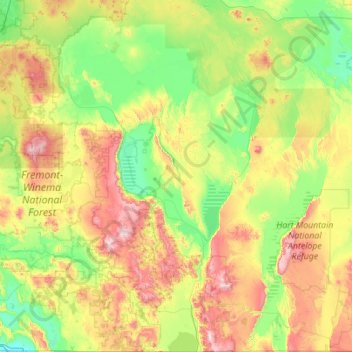
Naam: Topografische kaart Lake County, hoogte, reliëf.
Locatie: Lake County, Oregon, United States of America (41.99301 -121.35122 43.61761 -119.35940)
Gemiddelde hoogte: 1.540 m
Minimale hoogte: 1.233 m
Maximale hoogte: 2.530 m
Lake County ranges in elevation from 4,130 to 8,446 feet (1,259 to 2,574 m). The highest point in Lake County is Crane Mountain. The mountain is located 6 miles (9.7 km) north of the California border. Lake County has six other peaks with elevations above 8,000 feet (2,400 m), all located in the southern half of the county. Hager Mountain is the highest peak in the northern part of the county.
Andere topografische kaarten
Klik op een kaart om zijn topografie, zijn hoogte en zijn reliëf te bekijken.
Boring
United States of America > Oregon > Boring
Boring, Clackamas County, Oregon, 97009, United States of America
Gemiddelde hoogte: 183 m
Rhododendron
United States of America > Oregon > Rhododendron
Rhododendron, The Villages at Mount Hood, Clackamas County, Oregon, 97049, United States of America
Gemiddelde hoogte: 735 m
Iron Knob
United States of America > Oregon
Iron Knob, Jackson County, Oregon, United States of America
Gemiddelde hoogte: 861 m
Morton Island
United States of America > Oregon
Morton Island, Malheur County, Oregon, United States of America
Gemiddelde hoogte: 661 m
Wemme
United States of America > Oregon > Wemme
Wemme, The Villages at Mount Hood, Clackamas County, Oregon, 97067, United States of America
Gemiddelde hoogte: 494 m
Barlow
United States of America > Oregon > Barlow
Barlow, Clackamas County, Oregon, United States of America
Gemiddelde hoogte: 31 m
McKenzie River
United States of America > Oregon
McKenzie River, Lane County, Oregon, 97413, United States of America
Gemiddelde hoogte: 431 m
Hillsboro
United States of America > Oregon > Hillsboro
Hillsboro, Washington County, Oregon, United States of America
Gemiddelde hoogte: 53 m
Hail Creek
United States of America > Oregon
Hail Creek, Crook County, Oregon, United States of America
Gemiddelde hoogte: 1.412 m