
Topografische kaart Mount Cleveland
Interactieve kaart
Klik op de kaart om de hoogte weer te geven.
Over deze kaart
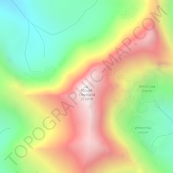
Naam: Topografische kaart Mount Cleveland, hoogte, reliëf.
Locatie: Mount Cleveland, Glacier County, Montana, United States (48.92495 -113.84811 48.92505 -113.84801)
Gemiddelde hoogte: 2.339 m
Minimale hoogte: 1.639 m
Maximale hoogte: 3.173 m
While not of great absolute elevation (the mountain is more than 2,300 ft (700 m) lower than Granite Peak, the highest peak in Montana), Mount Cleveland is notable for its large, steep rise above local terrain. For example, its west flank rises over 5,500 ft (1,700 m) in less than 2 mi (3.2 km); the northwest face, the steepest on the mountain, rises 4,000 ft (1,200 m) in less than 0.4 mi (0.64 km). The other faces show almost as much vertical relief. This scale and steepness of relief is quite rare in the contiguous United States. Mount Cleveland ranks 50th on the list of peaks in the contiguous U.S. with the greatest topographic prominence. The massif upon which Mount Cleveland is situated also includes 10,001-foot (3,048 m) Kaiser Point, which is the seventh-highest peak in the park and is only .67 mi (1.08 km) to the northeast.
Andere topografische kaarten
Klik op een kaart om zijn topografie, zijn hoogte en zijn reliëf te bekijken.
North Browning
United States > Montana > Glacier County
North Browning, Glacier County, Montana, United States
Gemiddelde hoogte: 1.336 m
South Browning
United States > Montana > Glacier County
South Browning, Glacier County, Montana, United States
Gemiddelde hoogte: 1.345 m
Many Glacier
United States > Montana > Glacier County
Many Glacier, Glacier County, Montana, United States
Gemiddelde hoogte: 1.658 m
Calf Robe Mountain
United States > Montana > Glacier County
Calf Robe Mountain, Glacier County, Montana, United States
Gemiddelde hoogte: 2.020 m
Bullhead Lake
United States > Montana > Glacier County
Bullhead Lake, Glacier County, Montana, United States
Gemiddelde hoogte: 1.848 m
Chief Mountain
United States > Montana > Glacier County
Chief Mountain, Glacier County, Montana, United States
Gemiddelde hoogte: 2.196 m
Bison
United States > Montana > Glacier County > Bison
Bison, Glacier County, Montana, United States
Gemiddelde hoogte: 1.577 m
Durham
United States > Montana > Glacier County > Durham
Durham, Glacier County, Montana, United States
Gemiddelde hoogte: 1.468 m
Saint Mary
United States > Montana > Glacier County
Saint Mary, Glacier County, Montana, United States
Gemiddelde hoogte: 1.430 m
Cracker Lake
United States > Montana > Glacier County
Cracker Lake, Glacier County, Montana, United States
Gemiddelde hoogte: 2.224 m
Pray Lake
United States > Montana > Glacier County
Pray Lake, Glacier County, Montana, United States
Gemiddelde hoogte: 1.717 m
Browning
United States > Montana > Glacier County
Browning, Glacier County, Montana, United States
Gemiddelde hoogte: 1.338 m
Babb
United States > Montana > Glacier County
Babb, Glacier County, Montana, 59411, United States
Gemiddelde hoogte: 1.432 m
East Flattop Mountain
United States > Montana > Glacier County
East Flattop Mountain, Glacier County, Montana, United States
Gemiddelde hoogte: 2.241 m
East Glacier Park Village
United States > Montana > Glacier County
East Glacier Park Village, Glacier County, Montana, 59434, United States
Gemiddelde hoogte: 1.530 m
Cut Bank
United States > Montana > Glacier County
Cut Bank, Glacier County, Montana, United States
Gemiddelde hoogte: 1.147 m