
Topografische kaart Many Glacier
Interactieve kaart
Klik op de kaart om de hoogte weer te geven.
Over deze kaart
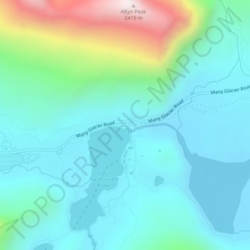
Naam: Topografische kaart Many Glacier, hoogte, reliëf.
Locatie: Many Glacier, Glacier County, Montana, United States (48.79042 -113.66757 48.81042 -113.64757)
Gemiddelde hoogte: 1.658 m
Minimale hoogte: 1.458 m
Maximale hoogte: 2.416 m
Andere topografische kaarten
Klik op een kaart om zijn topografie, zijn hoogte en zijn reliëf te bekijken.
North Browning
United States > Montana > Glacier County
North Browning, Glacier County, Montana, United States
Gemiddelde hoogte: 1.336 m
South Browning
United States > Montana > Glacier County
South Browning, Glacier County, Montana, United States
Gemiddelde hoogte: 1.345 m
Calf Robe Mountain
United States > Montana > Glacier County
Calf Robe Mountain, Glacier County, Montana, United States
Gemiddelde hoogte: 2.020 m
Bullhead Lake
United States > Montana > Glacier County
Bullhead Lake, Glacier County, Montana, United States
Gemiddelde hoogte: 1.848 m
Chief Mountain
United States > Montana > Glacier County
Chief Mountain, Glacier County, Montana, United States
Gemiddelde hoogte: 2.196 m
Bison
United States > Montana > Glacier County > Bison
Bison, Glacier County, Montana, United States
Gemiddelde hoogte: 1.577 m
Durham
United States > Montana > Glacier County > Durham
Durham, Glacier County, Montana, United States
Gemiddelde hoogte: 1.468 m
Saint Mary
United States > Montana > Glacier County
Saint Mary, Glacier County, Montana, United States
Gemiddelde hoogte: 1.430 m
Cracker Lake
United States > Montana > Glacier County
Cracker Lake, Glacier County, Montana, United States
Gemiddelde hoogte: 2.224 m
Mount Cleveland
United States > Montana > Glacier County
Mount Cleveland, Glacier County, Montana, United States
Gemiddelde hoogte: 2.339 m
Pray Lake
United States > Montana > Glacier County
Pray Lake, Glacier County, Montana, United States
Gemiddelde hoogte: 1.717 m
Babb
United States > Montana > Glacier County
Babb, Glacier County, Montana, 59411, United States
Gemiddelde hoogte: 1.432 m
East Flattop Mountain
United States > Montana > Glacier County
East Flattop Mountain, Glacier County, Montana, United States
Gemiddelde hoogte: 2.241 m
Browning
United States > Montana > Glacier County
Browning, Glacier County, Montana, United States
Gemiddelde hoogte: 1.338 m
East Glacier Park Village
United States > Montana > Glacier County
East Glacier Park Village, Glacier County, Montana, 59434, United States
Gemiddelde hoogte: 1.530 m
Cut Bank
United States > Montana > Glacier County
Cut Bank, Glacier County, Montana, United States
Gemiddelde hoogte: 1.147 m