
Topografische kaart Lansing
Interactieve kaart
Klik op de kaart om de hoogte weer te geven.
Over deze kaart
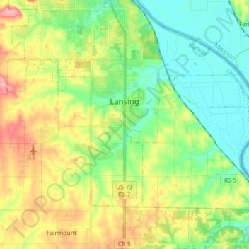
Naam: Topografische kaart Lansing, hoogte, reliëf.
Locatie: Lansing, Leavenworth County, Kansas, 66043, United States (39.20284 -94.96581 39.27422 -94.82651)
Gemiddelde hoogte: 266 m
Minimale hoogte: 225 m
Maximale hoogte: 337 m
Andere topografische kaarten
Klik op een kaart om zijn topografie, zijn hoogte en zijn reliëf te bekijken.
Maywood
United States > Kansas > Leavenworth County > Leavenworth
Maywood, Leavenworth, Leavenworth County, Kansas, 64092, United States
Gemiddelde hoogte: 246 m
Fairmount
United States > Kansas > Leavenworth County
Fairmount, Leavenworth County, Kansas, United States
Gemiddelde hoogte: 290 m
Leavenworth
United States > Kansas > Leavenworth County
Leavenworth, Leavenworth County, Kansas, United States
Gemiddelde hoogte: 268 m
Linwood
United States > Kansas > Leavenworth County
Linwood, Leavenworth County, Kansas, United States
Gemiddelde hoogte: 248 m
Hoge
United States > Kansas > Leavenworth County
Hoge, Leavenworth County, Kansas, United States
Gemiddelde hoogte: 276 m
Basehor
United States > Kansas > Leavenworth County
Basehor, Leavenworth County, Kansas, 66007, United States
Gemiddelde hoogte: 286 m
Fort Leavenworth
United States > Kansas > Leavenworth County > Leavenworth > Leavenworth
Fort Leavenworth, Leavenworth, Leavenworth County, Kansas, 66027, United States
Gemiddelde hoogte: 252 m
Leavenworth
United States > Kansas > Leavenworth County > Leavenworth
Leavenworth, Leavenworth County, Kansas, 66048, United States
Gemiddelde hoogte: 277 m