
Doe een donatie
Rust jezelf uit voor je volgende avontuur:
Als Amazon-partner verdient deze site een commissie op in aanmerking komende aankopen, zonder extra kosten voor jou.
Topografische kaart Terlingua
Klik op de kaart om de hoogte weer te geven.
Doe een donatie
Rust jezelf uit voor je volgende avontuur:
Als Amazon-partner verdient deze site een commissie op in aanmerking komende aankopen, zonder extra kosten voor jou.
Over deze kaart
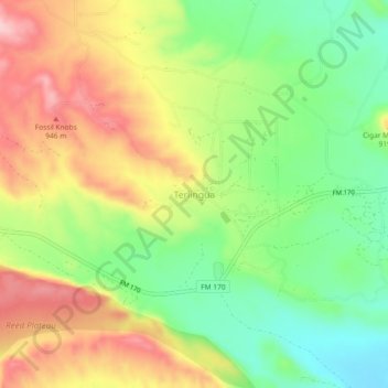
Naam: Topografische kaart Terlingua, hoogte, reliëf.
Locatie: Terlingua, Brewster County, Texas, United States (29.30159 -103.63602 29.34159 -103.59602)
Gemiddelde hoogte: 872 m
Minimale hoogte: 780 m
Maximale hoogte: 980 m
Doe een donatie
Rust jezelf uit voor je volgende avontuur:
Als Amazon-partner verdient deze site een commissie op in aanmerking komende aankopen, zonder extra kosten voor jou.
Andere topografische kaarten
Klik op een kaart om zijn topografie, zijn hoogte en zijn reliëf te bekijken.
Alpine
United States > Texas > Brewster County
Alpine (/ˈælpaɪn/ AL-pyne) is a city in the county seat of Brewster County, Texas, United States. The population was 5,905 at the 2010 census. The town has an elevation of 4,475 feet (1,364 m), and the surrounding mountain peaks are over 1 mile (1.6 km) above sea level. The university, hospital, library,…
Gemiddelde hoogte: 1.373 m
Big Bend National Park
United States > Texas > Brewster County
Big Bend National Park is an American national park located in West Texas, bordering Mexico. The park has national significance as the largest protected area of Chihuahuan Desert topography and ecology in the United States, and was named after a large bend in the Rio Grande/Río Bravo. The park protects more…
Gemiddelde hoogte: 934 m
Alpine
United States > Texas > Brewster County
Alpine (/ˈælpaɪn/ AL-pyne) is a city in and the county seat of Brewster County, Texas, United States. The population was 6,035 at the 2020 census. The town has an elevation of 4,462 feet (1,360 m), and the surrounding mountain peaks are over 1 mile (1.6 km) above sea level. A university, hospital, library,…
Gemiddelde hoogte: 1.373 m
Doe een donatie
Rust jezelf uit voor je volgende avontuur:
Als Amazon-partner verdient deze site een commissie op in aanmerking komende aankopen, zonder extra kosten voor jou.
Big Bend National Park
United States > Texas > Brewster County
Big Bend National Park is an American national park located in West Texas, bordering Mexico. The park has national significance as the largest protected area of Chihuahuan Desert topography and ecology in the United States, and was named after a large bend in the Rio Grande/Río Bravo. The park protects more…
Gemiddelde hoogte: 934 m