
Topografische kaart Yuma
Interactieve kaart
Klik op de kaart om de hoogte weer te geven.
Over deze kaart
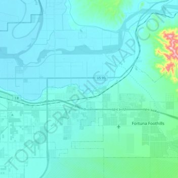
Naam: Topografische kaart Yuma, hoogte, reliëf.
Locatie: Yuma, Yuma County, Arizona, United States (32.65240 -114.65904 32.72622 -114.46608)
Gemiddelde hoogte: 78 m
Minimale hoogte: 38 m
Maximale hoogte: 477 m
Andere topografische kaarten
Klik op een kaart om zijn topografie, zijn hoogte en zijn reliëf te bekijken.
Yuma
United States > Arizona > Yuma County
Yuma, Yuma County, Arizona, 85364, United States
Gemiddelde hoogte: 69 m
Kofa National Wildlife Refuge
United States > Arizona > Yuma County
Kofa National Wildlife Refuge, Yuma County, Arizona, United States
Gemiddelde hoogte: 460 m
Tyson
United States > Arizona > Yuma County
Tyson, Yuma County, Arizona, United States
Gemiddelde hoogte: 94 m
Fortuna Foothills
United States > Arizona > Yuma County > Fortuna Foothills
Fortuna Foothills, Yuma County, Arizona, United States
Gemiddelde hoogte: 133 m