
Topografische kaart Tyson
Interactieve kaart
Klik op de kaart om de hoogte weer te geven.
Over deze kaart
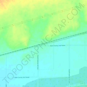
Naam: Topografische kaart Tyson, hoogte, reliëf.
Locatie: Tyson, Yuma County, Arizona, United States (32.77671 -113.90160 32.81671 -113.86160)
Gemiddelde hoogte: 94 m
Minimale hoogte: 83 m
Maximale hoogte: 113 m
Andere topografische kaarten
Klik op een kaart om zijn topografie, zijn hoogte en zijn reliëf te bekijken.
Yuma
United States > Arizona > Yuma County
Yuma, Yuma County, Arizona, 85364, United States
Gemiddelde hoogte: 69 m
Kofa National Wildlife Refuge
United States > Arizona > Yuma County
Kofa National Wildlife Refuge, Yuma County, Arizona, United States
Gemiddelde hoogte: 460 m
Fortuna Foothills
United States > Arizona > Yuma County > Fortuna Foothills
Fortuna Foothills, Yuma County, Arizona, United States
Gemiddelde hoogte: 133 m
Yuma
United States > Arizona > Yuma County
Yuma, Yuma County, Arizona, United States
Gemiddelde hoogte: 78 m