
Topografische kaart Orle
Interactieve kaart
Klik op de kaart om de hoogte weer te geven.
Over deze kaart
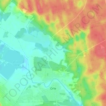
Naam: Topografische kaart Orle, hoogte, reliëf.
Gemiddelde hoogte: 43 m
Minimale hoogte: 19 m
Maximale hoogte: 77 m
Andere topografische kaarten
Klik op een kaart om zijn topografie, zijn hoogte en zijn reliëf te bekijken.
Perlino-Wybudowa
Poland > Pomeranian Voivodeship > Wejherowo County > Perlino
Perlino-Wybudowa, Perlino, gmina Gniewino, Wejherowo County, Pomeranian Voivodeship, 84-250, Poland
Gemiddelde hoogte: 58 m
Sopieszyno
Poland > Pomeranian Voivodeship > Wejherowo County
Sopieszyno, gmina Wejherowo, Wejherowo County, Pomeranian Voivodeship, Poland
Gemiddelde hoogte: 148 m
Szemud
Poland > Pomeranian Voivodeship > Wejherowo County > Szemud
Szemud, gmina Szemud, Wejherowo County, Pomeranian Voivodeship, Poland
Gemiddelde hoogte: 186 m
Przetoczyno
Poland > Pomeranian Voivodeship > Wejherowo County > Przetoczyno
Przetoczyno, gmina Szemud, Wejherowo County, Pomeranian Voivodeship, Poland
Gemiddelde hoogte: 163 m
Rumia
Poland > Pomeranian Voivodeship > Wejherowo County > Rumia
Rumia, Wejherowo County, Pomeranian Voivodeship, 84-230, Poland
Gemiddelde hoogte: 69 m
Reda
Poland > Pomeranian Voivodeship > Wejherowo County > Reda
Reda, Wejherowo County, Pomeranian Voivodeship, 84-240, Poland
Gemiddelde hoogte: 46 m
Zbychowo
Poland > Pomeranian Voivodeship > Wejherowo County > Zbychowo
Zbychowo, gmina Wejherowo, Wejherowo County, Pomeranian Voivodeship, 84-206, Poland
Gemiddelde hoogte: 148 m
Mierzyno
Poland > Pomeranian Voivodeship > Wejherowo County
Mierzyno, gmina Gniewino, Wejherowo County, Pomeranian Voivodeship, 84-250, Poland
Gemiddelde hoogte: 70 m
Wejherowo
Poland > Pomeranian Voivodeship > Wejherowo County > Wejherowo
Wejherowo, Wejherowo County, Pomeranian Voivodeship, Poland
Gemiddelde hoogte: 71 m