
Topografische kaart Tutira
Interactieve kaart
Klik op de kaart om de hoogte weer te geven.
Over deze kaart
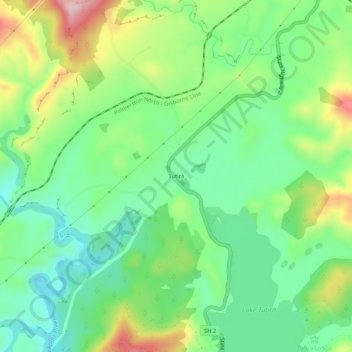
Naam: Topografische kaart Tutira, hoogte, reliëf.
Locatie: Tutira, Hastings District, Hawke's Bay, New Zealand (-39.22745 176.86119 -39.18745 176.90119)
Gemiddelde hoogte: 191 m
Minimale hoogte: 89 m
Maximale hoogte: 384 m
Andere topografische kaarten
Klik op een kaart om zijn topografie, zijn hoogte en zijn reliëf te bekijken.
Hastings
New Zealand > Hawke's Bay > Hastings District
Hastings, Hastings District, Hawke's Bay, 4122, New Zealand
Gemiddelde hoogte: 68 m
Te Haroto
New Zealand > Hawke's Bay > Hastings District
Te Haroto, Hastings District, Hawke's Bay, New Zealand
Gemiddelde hoogte: 647 m
Kereru
New Zealand > Hawke's Bay > Hastings District
Kereru, Hastings District, Hawke's Bay, New Zealand
Gemiddelde hoogte: 305 m
Havelock North
New Zealand > Hawke's Bay > Hastings District
Havelock North, Hastings District, Hawke's Bay, 4130, New Zealand
Gemiddelde hoogte: 45 m
Poukawa
New Zealand > Hawke's Bay > Hastings District
Poukawa, Hastings District, Hawke's Bay, New Zealand
Gemiddelde hoogte: 49 m
Twyford
New Zealand > Hawke's Bay > Hastings District > Hastings
Twyford, Hastings, Hastings District, Hawke's Bay, 4154, New Zealand
Gemiddelde hoogte: 19 m
Waikoau
New Zealand > Hawke's Bay > Hastings District
Waikoau, Hastings District, Hawke's Bay, New Zealand
Gemiddelde hoogte: 290 m
Mangateretere
New Zealand > Hawke's Bay > Hastings District > Hastings
Mangateretere, Hastings, Hastings District, Hawke's Bay, 4172, New Zealand
Gemiddelde hoogte: 9 m
Maraekakaho
New Zealand > Hawke's Bay > Hastings District > Maraekakaho
Maraekakaho, Hastings District, Hawke's Bay, New Zealand
Gemiddelde hoogte: 118 m
Matangi
New Zealand > Hawke's Bay > Hastings District > Hastings
Matangi, Hastings, Hastings District, Hawke's Bay, 4295, New Zealand
Gemiddelde hoogte: 187 m
Otatara Pā
New Zealand > Hawke's Bay > Hastings District > Napier > Waiohiki
Otatara Pā, Springfield Road, Waiohiki, Napier, Hastings District, Hawke's Bay, 4142, New Zealand
Gemiddelde hoogte: 31 m
Sherenden
New Zealand > Hawke's Bay > Hastings District > Sherenden
Sherenden, Hastings District, Hawke's Bay, New Zealand
Gemiddelde hoogte: 258 m
Lake Tutira
New Zealand > Hawke's Bay > Hastings District
Lake Tutira, Hastings District, Hawke's Bay, New Zealand
Gemiddelde hoogte: 197 m
Crownthorpe
New Zealand > Hawke's Bay > Hastings District
Crownthorpe, Hastings District, Hawke's Bay, New Zealand
Gemiddelde hoogte: 168 m
Maraetotara River
New Zealand > Hawke's Bay > Hastings District
Maraetotara River, Hastings District, Hawke's Bay, 4180, New Zealand
Gemiddelde hoogte: 105 m