
Topografische kaart Hope Mills
Interactieve kaart
Klik op de kaart om de hoogte weer te geven.
Over deze kaart
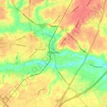
Naam: Topografische kaart Hope Mills, hoogte, reliëf.
Locatie: Hope Mills, Cumberland County, North Carolina, United States (34.92947 -78.99355 35.00970 -78.90120)
Gemiddelde hoogte: 49 m
Minimale hoogte: 19 m
Maximale hoogte: 69 m
Andere topografische kaarten
Klik op een kaart om zijn topografie, zijn hoogte en zijn reliëf te bekijken.
Fayetteville
United States > North Carolina > Cumberland County
Fayetteville, Cumberland County, North Carolina, United States
Gemiddelde hoogte: 48 m
Eaglewood Forest
United States > North Carolina > Cumberland County > Hope Mills
Eaglewood Forest, Hope Mills, Cumberland County, North Carolina, 28306, United States
Gemiddelde hoogte: 45 m
The Greens
United States > North Carolina > Cumberland County > Fayetteville
The Greens, Fayetteville, Cumberland County, North Carolina, 28311, United States
Gemiddelde hoogte: 52 m
Hillendale
United States > North Carolina > Cumberland County > Fayetteville
Hillendale, Fayetteville, Cumberland County, North Carolina, 28311, United States
Gemiddelde hoogte: 61 m
Winter Park
United States > North Carolina > Cumberland County > Fayetteville
Winter Park, Fayetteville, Cumberland County, North Carolina, 28304, United States
Gemiddelde hoogte: 58 m
Williams Village
United States > North Carolina > Cumberland County > Fayetteville
Williams Village, Fayetteville, Cumberland County, North Carolina, 28301, United States
Gemiddelde hoogte: 30 m