
Topografische kaart Norwalk
Interactieve kaart
Klik op de kaart om de hoogte weer te geven.
Over deze kaart
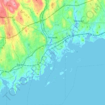
Naam: Topografische kaart Norwalk, hoogte, reliëf.
Gemiddelde hoogte: 24 m
Minimale hoogte: -7 m
Maximale hoogte: 145 m
Norwalk's topography is dominated by its coastline along Long Island Sound, the Norwalk River and its eastern and western banks, and the Norwalk Islands. The highest elevation is 315 feet above sea level on the fairway of the 16th hole of the Silvermine Golf Course, and the low elevation is sea level on Long Island Sound.
Andere topografische kaarten
Klik op een kaart om zijn topografie, zijn hoogte en zijn reliëf te bekijken.
Stamford
United States > Connecticut > Western Connecticut Planning Region
Stamford, Western Connecticut Planning Region, Connecticut, United States
Gemiddelde hoogte: 48 m
Greenwich
United States > Connecticut > Western Connecticut Planning Region
Greenwich, Western Connecticut Planning Region, Connecticut, United States
Gemiddelde hoogte: 57 m
Westport
United States > Connecticut > Western Connecticut Planning Region
Westport, Western Connecticut Planning Region, Connecticut, 06880, United States
Gemiddelde hoogte: 22 m
Ridgefield
United States > Connecticut > Western Connecticut Planning Region
Ridgefield, Western Connecticut Planning Region, Connecticut, 06877, United States
Gemiddelde hoogte: 183 m
Newtown
United States > Connecticut > Western Connecticut Planning Region
Newtown, Western Connecticut Planning Region, Connecticut, United States
Gemiddelde hoogte: 147 m
Belltown
United States > Connecticut > Western Connecticut Planning Region > Stamford
Belltown, Stamford, Western Connecticut Planning Region, Connecticut, 06906, United States
Gemiddelde hoogte: 32 m
Palmers Hill
United States > Connecticut > Western Connecticut Planning Region > Stamford
Palmers Hill, Stamford, Western Connecticut Planning Region, Connecticut, 06904, United States
Gemiddelde hoogte: 31 m
North Stamford
United States > Connecticut > Western Connecticut Planning Region > Stamford
North Stamford, Stamford, Western Connecticut Planning Region, Connecticut, 06903, United States
Gemiddelde hoogte: 89 m
Mianus
United States > Connecticut > Western Connecticut Planning Region > Greenwich
Mianus, Greenwich, Western Connecticut Planning Region, Connecticut, 06807, United States
Gemiddelde hoogte: 23 m
Redding
United States > Connecticut > Western Connecticut Planning Region
Redding, Western Connecticut Planning Region, Connecticut, United States
Gemiddelde hoogte: 160 m
Taylor Corners
United States > Connecticut > Western Connecticut Planning Region > New Fairfield
Taylor Corners, New Fairfield, Western Connecticut Planning Region, Connecticut, 06812, United States
Gemiddelde hoogte: 226 m
Bethel
United States > Connecticut > Western Connecticut Planning Region
Bethel, Western Connecticut Planning Region, Connecticut, 06801, United States
Gemiddelde hoogte: 157 m
Beckettville
United States > Connecticut > Western Connecticut Planning Region > Danbury
Beckettville, Danbury, Western Connecticut Planning Region, Connecticut, 06813, United States
Gemiddelde hoogte: 155 m
Contentment Island
United States > Connecticut > Western Connecticut Planning Region > Darien
Contentment Island, Darien, Western Connecticut Planning Region, Connecticut, 06853, United States
Gemiddelde hoogte: 63 m
New Milford
United States > Connecticut > Western Connecticut Planning Region
New Milford, Western Connecticut Planning Region, Connecticut, United States
Gemiddelde hoogte: 193 m
Danbury
United States > Connecticut > Western Connecticut Planning Region
Danbury, Western Connecticut Planning Region, Connecticut, United States
Gemiddelde hoogte: 174 m
New Canaan
United States > Connecticut > Western Connecticut Planning Region
New Canaan, Western Connecticut Planning Region, Connecticut, 06840, United States
Gemiddelde hoogte: 102 m
Honey Hill
United States > Connecticut > Western Connecticut Planning Region > Wilton
Honey Hill, Wilton, Western Connecticut Planning Region, Connecticut, 06829, United States
Gemiddelde hoogte: 126 m
New Fairfield
United States > Connecticut > Western Connecticut Planning Region
New Fairfield, Fairfield County, Connecticut, 06812, United States
Gemiddelde hoogte: 206 m
Danbury
United States > Connecticut > Western Connecticut Planning Region
Danbury, Western Connecticut Planning Region, Connecticut, United States
Gemiddelde hoogte: 174 m
Stamford
United States > Connecticut > Western Connecticut Planning Region
Stamford, Western Connecticut Planning Region, Connecticut, United States
Gemiddelde hoogte: 48 m
Darien
United States > Connecticut > Western Connecticut Planning Region
Darien, Western Connecticut Planning Region, Connecticut, 06820, United States
Gemiddelde hoogte: 12 m
Hunting Ridge
United States > Connecticut > Western Connecticut Planning Region > Stamford
Hunting Ridge, Stamford, Western Connecticut Planning Region, Connecticut, 06903, United States
Gemiddelde hoogte: 81 m
Old Baldy
United States > Connecticut > Western Connecticut Planning Region > Norwalk
Old Baldy, Norwalk, Western Connecticut Planning Region, Connecticut, 06853, United States
Gemiddelde hoogte: 59 m