
Topografische kaart Danbury
Interactieve kaart
Klik op de kaart om de hoogte weer te geven.
Over deze kaart
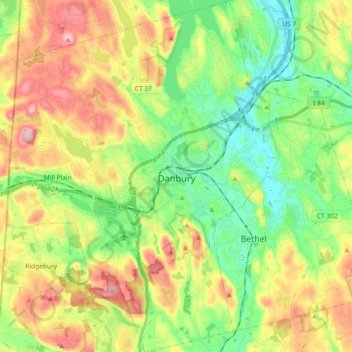
Naam: Topografische kaart Danbury, hoogte, reliëf.
Gemiddelde hoogte: 174 m
Minimale hoogte: 77 m
Maximale hoogte: 320 m
According to the United States Census Bureau, Danbury has a total area of 44.3 square miles (115 km2), of which 42.1 square miles (109 km2) is land and 2.2 square miles (5.7 km2), or 4.94%, is water. The city is located in the foothills of the Berkshire Mountains on low-lying land just south of Candlewood Lake (the City includes the southern parts of the lake). It developed along the Still River, which flows generally from west to east through the city before joining the Housatonic River. The city's terrain includes rolling hills and not-very-tall mountains to the west and northwest called the Western Highland. Ground elevations in the city range from 378 feet to 1,050 feet above sea level.
Andere topografische kaarten
Klik op een kaart om zijn topografie, zijn hoogte en zijn reliëf te bekijken.
Greenwich
United States > Connecticut > Western Connecticut Planning Region
Greenwich, Western Connecticut Planning Region, Connecticut, United States
Gemiddelde hoogte: 57 m
Westport
United States > Connecticut > Western Connecticut Planning Region
Westport, Western Connecticut Planning Region, Connecticut, 06880, United States
Gemiddelde hoogte: 22 m
Stamford
United States > Connecticut > Western Connecticut Planning Region
Stamford, Western Connecticut Planning Region, Connecticut, United States
Gemiddelde hoogte: 48 m
Ridgefield
United States > Connecticut > Western Connecticut Planning Region
Ridgefield, Western Connecticut Planning Region, Connecticut, 06877, United States
Gemiddelde hoogte: 183 m
Newtown
United States > Connecticut > Western Connecticut Planning Region
Newtown, Western Connecticut Planning Region, Connecticut, United States
Gemiddelde hoogte: 147 m
Belltown
United States > Connecticut > Western Connecticut Planning Region > Stamford
Belltown, Stamford, Western Connecticut Planning Region, Connecticut, 06906, United States
Gemiddelde hoogte: 32 m
Palmers Hill
United States > Connecticut > Western Connecticut Planning Region > Stamford
Palmers Hill, Stamford, Western Connecticut Planning Region, Connecticut, 06904, United States
Gemiddelde hoogte: 31 m
North Stamford
United States > Connecticut > Western Connecticut Planning Region > Stamford
North Stamford, Stamford, Western Connecticut Planning Region, Connecticut, 06903, United States
Gemiddelde hoogte: 89 m
Mianus
United States > Connecticut > Western Connecticut Planning Region > Greenwich
Mianus, Greenwich, Western Connecticut Planning Region, Connecticut, 06807, United States
Gemiddelde hoogte: 23 m
Redding
United States > Connecticut > Western Connecticut Planning Region
Redding, Western Connecticut Planning Region, Connecticut, United States
Gemiddelde hoogte: 160 m
Taylor Corners
United States > Connecticut > Western Connecticut Planning Region > New Fairfield
Taylor Corners, New Fairfield, Western Connecticut Planning Region, Connecticut, 06812, United States
Gemiddelde hoogte: 226 m
Bethel
United States > Connecticut > Western Connecticut Planning Region
Bethel, Western Connecticut Planning Region, Connecticut, 06801, United States
Gemiddelde hoogte: 157 m
Beckettville
United States > Connecticut > Western Connecticut Planning Region > Danbury
Beckettville, Danbury, Western Connecticut Planning Region, Connecticut, 06813, United States
Gemiddelde hoogte: 155 m
Contentment Island
United States > Connecticut > Western Connecticut Planning Region > Darien
Contentment Island, Darien, Western Connecticut Planning Region, Connecticut, 06853, United States
Gemiddelde hoogte: 63 m
Norwalk
United States > Connecticut > Western Connecticut Planning Region
Norwalk, Western Connecticut Planning Region, Connecticut, United States
Gemiddelde hoogte: 24 m
New Milford
United States > Connecticut > Western Connecticut Planning Region
New Milford, Western Connecticut Planning Region, Connecticut, United States
Gemiddelde hoogte: 193 m
Danbury
United States > Connecticut > Western Connecticut Planning Region
Danbury, Western Connecticut Planning Region, Connecticut, United States
Gemiddelde hoogte: 174 m
New Canaan
United States > Connecticut > Western Connecticut Planning Region
New Canaan, Western Connecticut Planning Region, Connecticut, 06840, United States
Gemiddelde hoogte: 102 m
Honey Hill
United States > Connecticut > Western Connecticut Planning Region > Wilton
Honey Hill, Wilton, Western Connecticut Planning Region, Connecticut, 06829, United States
Gemiddelde hoogte: 126 m
New Fairfield
United States > Connecticut > Western Connecticut Planning Region
New Fairfield, Fairfield County, Connecticut, 06812, United States
Gemiddelde hoogte: 206 m
Stamford
United States > Connecticut > Western Connecticut Planning Region
Stamford, Western Connecticut Planning Region, Connecticut, United States
Gemiddelde hoogte: 48 m
Darien
United States > Connecticut > Western Connecticut Planning Region
Darien, Western Connecticut Planning Region, Connecticut, 06820, United States
Gemiddelde hoogte: 12 m
Hunting Ridge
United States > Connecticut > Western Connecticut Planning Region > Stamford
Hunting Ridge, Stamford, Western Connecticut Planning Region, Connecticut, 06903, United States
Gemiddelde hoogte: 81 m
Old Baldy
United States > Connecticut > Western Connecticut Planning Region > Norwalk
Old Baldy, Norwalk, Western Connecticut Planning Region, Connecticut, 06853, United States
Gemiddelde hoogte: 59 m