
Topografische kaart Santa Paula
Interactieve kaart
Klik op de kaart om de hoogte weer te geven.
Over deze kaart
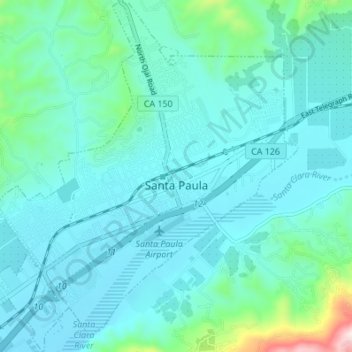
Naam: Topografische kaart Santa Paula, hoogte, reliëf.
Gemiddelde hoogte: 148 m
Minimale hoogte: 62 m
Maximale hoogte: 682 m
On October 31, 2019, the Maria Fire was reported burning at the top of South Mountain between Santa Paula and Somis and expanded throughout that evening. Heavily influenced by 20–30 mph (32–48 km/h) winds within the canyons, the fire became a full scale conflagration, growing from 50 to 750 acres (20 to 304 ha) inside an hour, to over 4,000 acres (16 km2) after several hours. The fire worked its way north towards Santa Paula where the topography of the Santa Clara River Valley which can serve as a funnel for Santa Ana winds. Mandatory evacuations were ordered for a wide swath of over 1,800 homes surrounding the fire area, affecting over 7,500 residences.
Andere topografische kaarten
Klik op een kaart om zijn topografie, zijn hoogte en zijn reliëf te bekijken.
Ojai
United States > California > Ventura County
Ojai, Ventura County, California, 93023, United States
Gemiddelde hoogte: 289 m
Oak View
United States > California > Ventura County
Oak View, Ventura County, CAL Fire Southern Region, California, 93022, United States
Gemiddelde hoogte: 184 m
Jasmine Glen Estates
United States > California > Ventura County > Simi Valley
Jasmine Glen Estates, Simi Valley, Ventura County, CAL Fire Southern Region, California, 90363, United States
Gemiddelde hoogte: 331 m
San Buenaventura (Ventura)
United States > California > Ventura County
San Buenaventura (Ventura), Ventura County, CAL Fire Southern Region, California, United States
Gemiddelde hoogte: 158 m
SSFL South Buffer
United States > California > Ventura County
SSFL South Buffer, Ventura County, CAL Fire Contract Counties, California, United States
Gemiddelde hoogte: 504 m
Port Hueneme
United States > California > Ventura County
Port Hueneme, Ventura County, CAL Fire Southern Region, California, United States
Gemiddelde hoogte: 7 m
Lake Sherwood
United States > California > Ventura County
Lake Sherwood, Ventura County, California, United States
Gemiddelde hoogte: 332 m
Newbury Park
United States > California > Ventura County > Thousand Oaks > Newbury Park
Newbury Park, Thousand Oaks, Ventura County, California, 91320, United States
Gemiddelde hoogte: 262 m
Somis
United States > California > Ventura County
Somis, Ventura County, CAL Fire Southern Region, California, 93066, United States
Gemiddelde hoogte: 112 m
Simi Valley
United States > California > Ventura County > Simi Valley
Simi Valley, Ventura County, California, 93063-2364, United States
Gemiddelde hoogte: 379 m
Simi Valley
United States > California > Ventura County
Simi Valley, Ventura County, California, United States
Gemiddelde hoogte: 405 m
Thousand Oaks
United States > California > Ventura County
Thousand Oaks, Ventura County, California, United States
Gemiddelde hoogte: 333 m
Strathearn
United States > California > Ventura County > Simi Valley
Strathearn, Simi Valley, Ventura County, CAL Fire Southern Region, California, 93065, United States
Gemiddelde hoogte: 261 m
Greenwich Village
United States > California > Ventura County > Thousand Oaks > Greenwich Village
Greenwich Village, Thousand Oaks, Ventura County, California, 91360-4401, United States
Gemiddelde hoogte: 275 m
Casitas Springs
United States > California > Ventura County > Ventura > Casitas Springs
Casitas Springs, Ventura, Ventura County, California, 93022, United States
Gemiddelde hoogte: 182 m
Johnson Creek Park
United States > California > Ventura County > Oxnard > Pleasant Valley Mobile Home Park
Johnson Creek Park, Pleasant Valley Mobile Home Park, Oxnard, Ventura County, California, United States
Gemiddelde hoogte: 10 m
Oxnard
United States > California > Ventura County
Oxnard, Ventura County, California, United States
Gemiddelde hoogte: 16 m
Anacapa Island
United States > California > Ventura County
Anacapa Island, Ventura County, California, United States
Gemiddelde hoogte: 4 m
Thousand Oaks
United States > California > Ventura County > Thousand Oaks
Thousand Oaks, Ventura County, California, United States
Gemiddelde hoogte: 303 m
Ventura
United States > California > Ventura County
Ventura, Ventura County, CAL Fire Southern Region, California, United States
Gemiddelde hoogte: 120 m
Camarillo
United States > California > Ventura County
Camarillo, Ventura County, CAL Fire Southern Region, California, United States
Gemiddelde hoogte: 90 m