
Topografische kaart Alamogordo
Interactieve kaart
Klik op de kaart om de hoogte weer te geven.
Over deze kaart
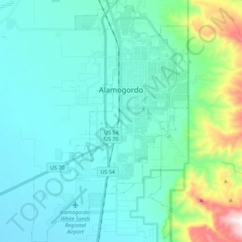
Naam: Topografische kaart Alamogordo, hoogte, reliëf.
Locatie: Alamogordo, Otero County, New Mexico, United States (32.81874 -106.01686 32.94756 -105.91772)
Gemiddelde hoogte: 1.515 m
Minimale hoogte: 1.248 m
Maximale hoogte: 2.467 m
As of 2010, Alamogordo had a total area of 19.3 square miles (50.0 km2), all of it land. The city is located at an elevation of 4,336 feet (1,322 m) on the western flank of the Sacramento Mountains and on the eastern edge of the Tularosa Basin. It lies within the Rio Grande rift and in the northernmost part of the Chihuahuan Desert.:36 Tectonic activity is low in the Tularosa Basin. Plants native to the area are typical of the southern New Mexico foothills and include creosote bush, mesquite, saltbush, cottonwood, desert willow, and many species of cactus and yucca.
Andere topografische kaarten
Klik op een kaart om zijn topografie, zijn hoogte en zijn reliëf te bekijken.
Cloudcroft
United States > New Mexico > Otero County
Cloudcroft, Otero County, New Mexico, United States
Gemiddelde hoogte: 2.643 m
Alamorosa
United States > New Mexico > Otero County
Alamorosa, Otero County, New Mexico, 88337, United States
Gemiddelde hoogte: 1.365 m
La Luz
United States > New Mexico > Otero County
La Luz, Otero County, New Mexico, 88337, United States
Gemiddelde hoogte: 1.452 m
Orogrande
United States > New Mexico > Otero County
Orogrande, Otero County, New Mexico, 88342, United States
Gemiddelde hoogte: 1.285 m
Weed
United States > New Mexico > Otero County
Weed, Otero County, New Mexico, 88354, United States
Gemiddelde hoogte: 2.212 m
Timberon
United States > New Mexico > Otero County
Timberon, Otero County, New Mexico, 88350, United States
Gemiddelde hoogte: 2.181 m
Apache
United States > New Mexico > Otero County
Apache, Otero County, New Mexico, United States
Gemiddelde hoogte: 1.957 m
Cloudcroft
United States > New Mexico > Otero County > Cloudcroft
Cloudcroft, Otero County, New Mexico, 88317, United States
Gemiddelde hoogte: 2.636 m
White Sands National Park
United States > New Mexico > Otero County
White Sands National Park, Otero County, New Mexico, United States
Gemiddelde hoogte: 1.214 m
Alamogordo
United States > New Mexico > Otero County
Alamogordo, Otero County, New Mexico, 88310, United States
Gemiddelde hoogte: 1.644 m
La Luz
United States > New Mexico > Otero County
La Luz, Otero County, New Mexico, 88337, United States
Gemiddelde hoogte: 1.493 m
High Rolls
United States > New Mexico > Otero County
High Rolls, Otero County, New Mexico, 88325, United States
Gemiddelde hoogte: 2.036 m
Mayhill
United States > New Mexico > Otero County
Mayhill, Otero County, New Mexico, United States
Gemiddelde hoogte: 2.104 m
Sacramento
United States > New Mexico > Otero County
Sacramento, Otero County, New Mexico, 88347, United States
Gemiddelde hoogte: 2.320 m