
Topografische kaart San Bernardo
Interactieve kaart
Klik op de kaart om de hoogte weer te geven.
Over deze kaart
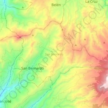
Naam: Topografische kaart San Bernardo, hoogte, reliëf.
Locatie: San Bernardo, Nariño, Colombia (1.49161 -77.07252 1.57588 -76.93612)
Gemiddelde hoogte: 2.480 m
Minimale hoogte: 1.621 m
Maximale hoogte: 3.672 m
Andere topografische kaarten
Klik op een kaart om zijn topografie, zijn hoogte en zijn reliëf te bekijken.
LA BRAVA - R?O GUANA
Colombia > Nariño > Tumaco > Kaunapi
LA BRAVA - R?O GUANA, Kaunapi, Tumaco, Pacífico Sur, Nariño, Colombia
Gemiddelde hoogte: 18 m
San Fransico (6)
Colombia > Nariño > Contadero > Contadero
San Fransico (6), Contadero, Ex-Providencia de Obando, Nariño, Colombia
Gemiddelde hoogte: 2.804 m