
Topografische kaart Woodland Park
Interactieve kaart
Klik op de kaart om de hoogte weer te geven.
Over deze kaart
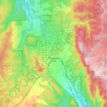
Naam: Topografische kaart Woodland Park, hoogte, reliëf.
Gemiddelde hoogte: 2.652 m
Minimale hoogte: 2.445 m
Maximale hoogte: 2.884 m
The area is characterized by the abundance of large granite rocks and alpine meadows, as well as its consistently high elevation ranging between 8,200 and 10,000 feet above sea level. The climate is considered arid which causes the surrounding forests to become very dry, posing a significant fire threat in combination with a large proportion of lightning strikes and high mountain winds. Fire restrictions are common.
Andere topografische kaarten
Klik op een kaart om zijn topografie, zijn hoogte en zijn reliëf te bekijken.
Victor
United States > Colorado > Teller County
Victor, Teller County, Colorado, United States
Gemiddelde hoogte: 2.974 m
Midland
United States > Colorado > Teller County
Midland, Teller County, Colorado, United States
Gemiddelde hoogte: 2.874 m
Cripple Creek
United States > Colorado > Teller County
Cripple Creek, Teller County, Colorado, United States
Gemiddelde hoogte: 2.946 m
Florissant
United States > Colorado > Teller County
Florissant, Teller County, Colorado, United States
Gemiddelde hoogte: 2.556 m
Divide
United States > Colorado > Teller County
Divide, Teller County, Colorado, United States
Gemiddelde hoogte: 2.796 m
Woodland Park
United States > Colorado > Teller County > Woodland Park
Woodland Park, Teller County, Colorado, 80863, United States
Gemiddelde hoogte: 2.657 m
Copper Mountain
United States > Colorado > Teller County
Copper Mountain, Teller County, Colorado, 80813, United States
Gemiddelde hoogte: 2.946 m
Squaw Mountain
United States > Colorado > Teller County
Squaw Mountain, Teller County, Colorado, 80860, United States
Gemiddelde hoogte: 2.977 m