
Topografische kaart Gananoque Lake
Interactieve kaart
Klik op de kaart om de hoogte weer te geven.
Over deze kaart
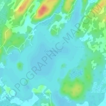
Naam: Topografische kaart Gananoque Lake, hoogte, reliëf.
Gemiddelde hoogte: 92 m
Minimale hoogte: 81 m
Maximale hoogte: 131 m
Andere topografische kaarten
Klik op een kaart om zijn topografie, zijn hoogte en zijn reliëf te bekijken.
Gananoque Lake
Canada > Ontario > Leeds and the Thousand Islands
Gananoque Lake, Pike Bay Line, Leeds and the Thousand Islands, Leeds and Grenville Counties, Ontario, Canada
Gemiddelde hoogte: 90 m
Gananoque River
Canada > Ontario > Leeds and the Thousand Islands > Willowbank
Gananoque River, Turn Around Road, Willowbank, Leeds and the Thousand Islands, Leeds and Grenville Counties, Eastern Ontario, Ontario, K7G 1G4, Canada
Gemiddelde hoogte: 92 m
Southern Water
Canada > Ontario > Leeds and the Thousand Islands > Outlet
Southern Water, Outlet, Leeds and the Thousand Islands, Leeds and Grenville Counties, Eastern Ontario, Ontario, Canada
Gemiddelde hoogte: 93 m
Ivy Lea
Canada > Ontario > Leeds and the Thousand Islands > Ivy Lea
Ivy Lea, Leeds and the Thousand Islands, Leeds and Grenville Counties, Eastern Ontario, Ontario, K0E 1L0, Canada
Gemiddelde hoogte: 87 m